
On leaving the Lake District after the Lakeland 100, we went to Glasgow to see Sharon’s Dad. As Sharon does all the driving we decided to split up the journey back. The first part of the plan was to spend Saturday night in Penrith and finish the journey on Sunday. Our journey from Penrith would take us along the A66 and past God’s Bridge. Sharon was quite keen on the idea of stopping and having a look at God’s Bridge. I also wanted to see God’s Bridge as it was on the small list – along with Snowdon and Pen-y-ghent – of ‘Thing’s I’ve only seen in the dark’. I crossed it on the Spine Race, I only knew that because I was with a couple of other runners at the time, one of whom told me I was crossing God’s Bridge. I can honestly say that otherwise I would have crossed it and been none the wiser.
Anyway this appeared to be a perfect opportunity to recce a bit of the Pennine Way and see the bridge. A further night was booked in a hotel in Grantham to allow us a bit more time to run, at the expense of an early start on Monday to get to work before 9:30.
I had my GPS with me from Lakeland but I’d deleted the Spine routes from it so I’d have to do a bit of route finding on the fly. Fortunately there is a ‘Bowes Loop’ at that point on the Pennine Way so I came up with something that almost looked like a plan if you didn’t look to closely. We would start in Bowes, run to God’s Bridge, recce the bit of the Pennine Way from there to Blackton Reservoir and return to Bowes on the ‘Bowes Loop’ – what could possibly go wrong?
Usually the phrase ‘What could possibly go wrong?’ is followed by a litany of disasters, indicating that the correct answer was ‘Pretty much everything’. Well not this time! Despite the lack of planning and minimal navigational aids, we executed our plan very well. We parked at the perfect location in Bowes (although this was a bit of a fluke as I wasn’t quite sure where we came back into the town) and headed west to God’s Bridge.
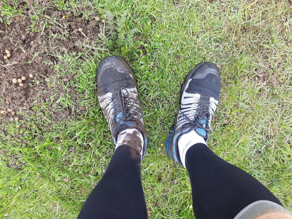
To be fair the first bit of navigation was hard to get wrong. God’s Bridge is over the river Greta (which had nothing to say on the subject of the environment) which flows past Bowes, it’s also near the A66 underpass so I would have had to really work at it to go massively off course – although from Spine experience, a few days of sleep deprivation might have done it. My navigation wasn’t perfect, I followed a path along Sleightholme Beck instead of the Pennine Way for about 500m, and just before God’s Bridge I took us along a farm track instead of the footpath but no one shot us or shouted at us and we arrived at said bridge so I’m taking that as a win.
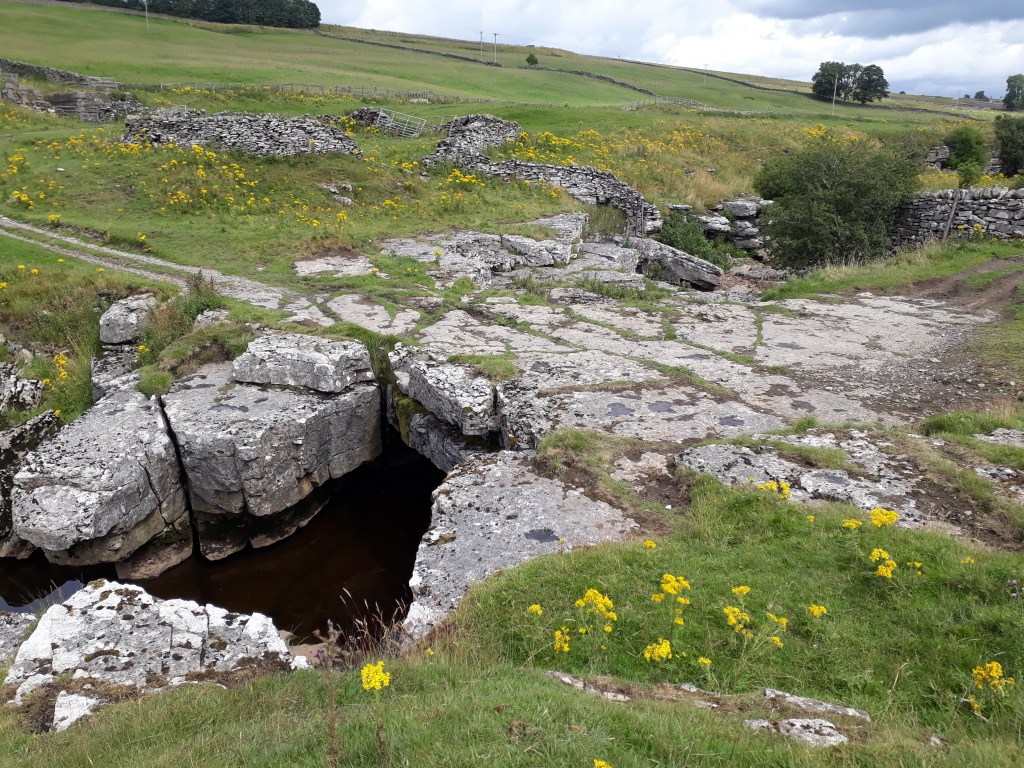
So what is so special about God’s Bridge? Why is it considered the property of a deity? I’ll let Wikipedia explain:
‘God’s Bridge is a Site of Special Scientific Interest in the Teesdale district of south-west County Durham, England. It is a natural limestone bridge over the River Greta, just over 3 km upstream from the village of Bowes.
The bridge was formed by a process of cave development in the limestone beneath the river bed and is the best example in Britain of a natural bridge formed in this way. The SSSI covers a portion of the river above and below the bridge where shallow cave development by solutional activity is still taking place.’

When I crossed it previously it was dark. As you can see it is an excellent bridge, with no real approach or exit ramps or steps so I think I can be forgiven for crossing it without noticing.

The A66 underpass was a lot more rural than I remembered from the impression I got in the dark. I thought it was graffitied and that the road was more visible (not sure why I thought that, given it was dark) but the path goes along the side of a field and into an arched corrugated iron tunnel under the road before emerging on the North side of the A66.
When I got to this point on the Spine Race the obvious path from the gate after the underpass very slightly cut the corner compared to the ‘official’ route. I took the obvious path again. Technically that could be construed as cheating I suppose but it would be quite harsh to be penalised for cutting maybe 20 yards off 268 miles, I feel.
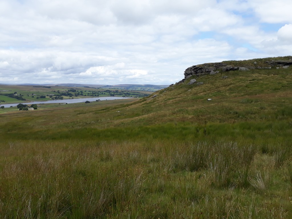
Once I was on Cotherstone Moor, things felt reassuringly familiar. I found the same rock to cross Rove Gill without getting my feet wet – however I did also find a very small peat bog I didn’t step into last time…
The path continued on to a shelter at Deepdale (which I’m fairly sure was locked when I did the Spine but was open on this occasion). We then passed ‘The Great Allotment’ – which was disappointingly devoid of people growing potatoes or sitting in sheds or doing any of the things one associates with allotments.

For the last half a mile of Cotherstone Moor I followed a path which was almost but not quite the Pennine Way as shown on an OS map. Interestingly I followed exactly the same route on the actual race. This time I probably added 20 yards to my distance and came out on a road not more than 10 yards from the official exit from Cotherstone Moor.

We were escorted by a goose and some goslings to Clove Lodge and shortly after left the Pennine Way proper to turn onto the Bowes Loop for the return journey.

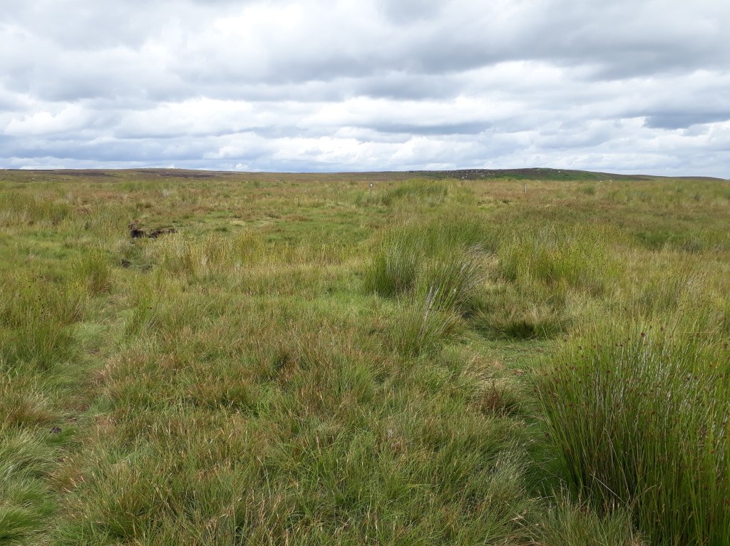
The Bowes Loop started well with some nice views back to the reservoir. The path was fairly clear apart from across one boggy field. it looked as if people had taken several different routes, presumably to try and avoid the boggiest bits. I tried to just keep heading in the right direction rather than keep trying ot find the exact path. I think this was one of my mistakes on the Spine Race, I spent a lot of time going sideways trying to find the path as indicated on the GPS, rather than making forward progress.
We started to climb away from the reservoirs and farmland, and back onto the moor. We passed under the shadow of Robin Hood’s hole according to the map, although it didn’t look much like a hole to me.
Shortly after this it seemed to become quite important that we stayed on the path…
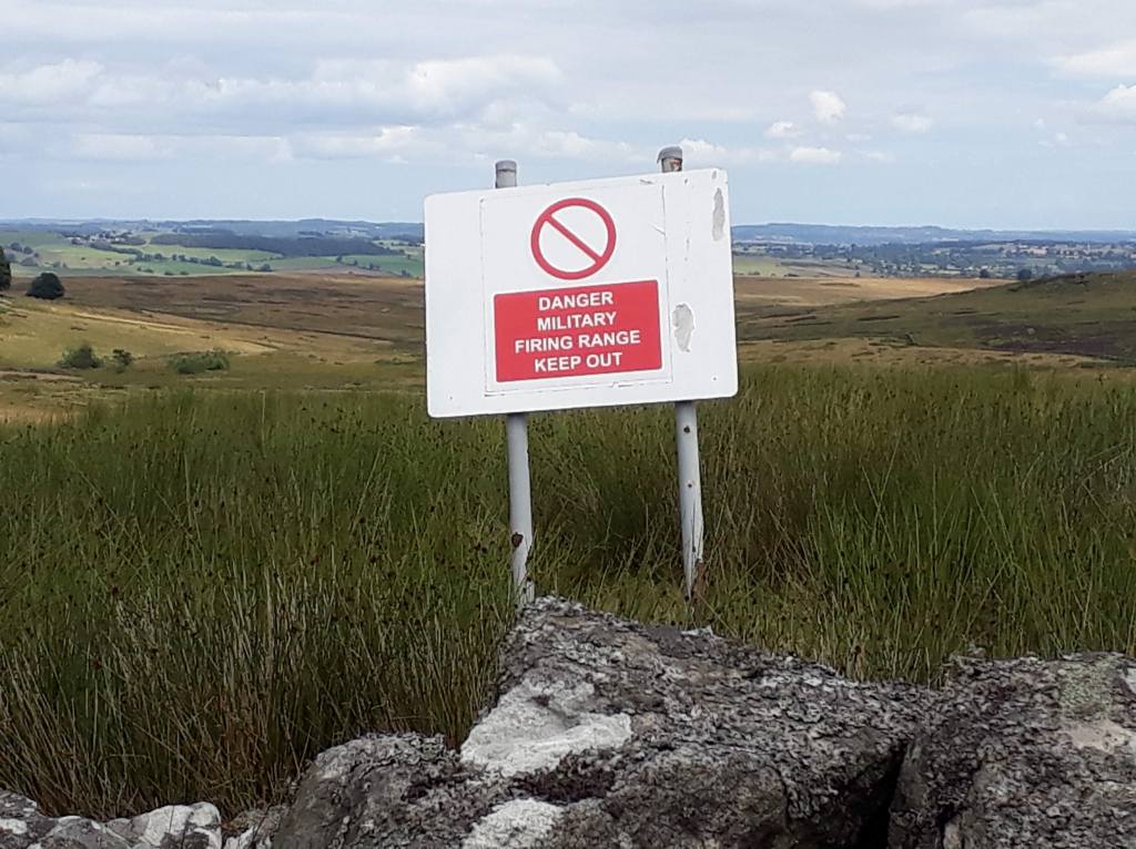
Fortunately the path was quite obvious and, more importantly, so was the boundary of the firing range.

As we got nearer to Bowes and came to Stoney Keld, we drifted a little off the path as marked on the GPS. At the time I wasn’t too bothered as we still appeared to be on a path and it would ultimately take us to the same place. Had I known more about the history of RAF Bowes Moor, the site of which we were now walking across, I might have been a little more careful about our exact route. As we rejoined the road a sign gave us a hint…
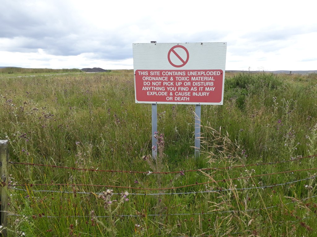
RAF Bowes Moor was a storage site for chemical weapons during the Second World War. Wikipedia can provide more details but I’ll just quote one small part: ‘Originally, the weapons were left piled up in the open with tarpaulins on them, however, sheep ate the covers which dislodged the weapons and so hardstandings were built to house the weapons. Most weapons were then stored inside buildings, except the 250 lb (110 kg) bombs which were left outside, however, sheep-proof fencing was erected around the whole site.’
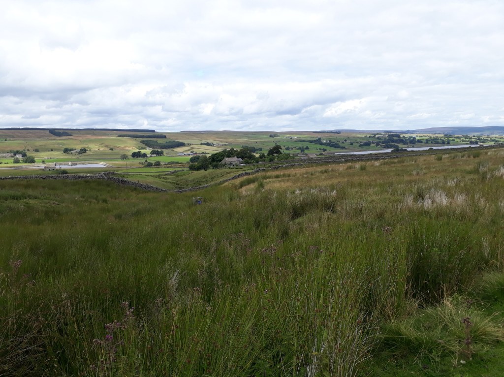
Having avoided being shot, blown up or poisoned (and, even more surprisingly, getting lost), the last part of our journey took us on a country road towards Bowes. By now my feet were suffering on the hard surface and Sharon was delighted to find that she was having to wait for me rather than vice-versa. As we came into Bowes we got a nice view of the castle and the even more welcome sight of the car, which, it turned out, was parked perfectly on our loop so no running back into Bowes to find it.

So what did I learn and did the recce achieve anything? Well ignoring anything else the ‘Bowes Loop’ is quite a nice little run and can be recommended to anyone that finds themselves in that part of the world. I was very pleased at how much of the Pennine Way I remembered. I was however particularly interested in how my perception of the A66 underpass deviated from reality. On the race I was there on my third night and had had maybe 3 hours sleep in total since the start of the race. This would seem to suggest that apart from obvious hallucinations, sleep deprivation (and possibly inadequate fuelling) can cause more subtle changes in perception. These are perhaps more concerning as they have the potential to be more disorientating than full blown ‘obvious’ hallucinations.
On a map or on a GPS track, there is THE Pennine Way. On the ground this can be less of a certainty. Also GPS positioning is only accurate to within a few metres so some common sense is needed – simply moving such that your location on the GPS is exactly on the track you are trying to follow does not mean you will be on a path! Add to this the fact that if the ground is boggy people may well take a different path (or several different paths as conditions change) and it becomes more important to be going the right way than trying to be on a path which exactly matches the GPS track – it may not exist. I think on the Spine I spent way too long looking for non-existent paths and not long enough making progress in the right direction. On this recce, especially once we were on the Bowes Loop and I had no previous experience of the route, I tried to take us the right way rather than be constantly looking for an exact path. OK I took us through a ex-chemical weapons dump in doing so and so maybe that isn’t always the right approach but there should be some middle ground there somewhere.
The recce also served two more linked purposes. At the moment I am very focussed on Spine 2022. It’s going to be hard to keep that focus for almost 11 more months so anything directly linked to the race will help. I also said I would update this blog on a regular basis but it might be hard to think of vaguely interesting things to write without the odd recce to report on!
So 4 miles recced, 264 more to do! It really does feel that the only way is Pennine…
