My plan was to spend at most two hours at Checkpoint One. However my phone had other plans. Due (I guess) to a combination of cold and poor mobile signal, the battery was down to 8% and was going to take 2 hours 30 minutes to recharge. I had options, first off, the ‘kit requirement’ for a phone is that it is charged to at least 50% before leaving a checkpoint. Secondly, I had a power bank I was carrying in my pack as an emergency backup if anything needed charging on the trail. As I clearly wasn’t going to be setting any course records, I decided to wait for my phone to fully charge. The next leg was the longest and would take me in excess of 24 hours so I would prefer my phone to be fully charged. The power bank was supposed to be for emergencies and anyway I didn’t really want to be faffing with charging my phone on the course if I didn’t have to, so I stayed a little longer than intended at CP1.
I should have used the time to pay a little more attention to my feet. Overall they were in great condition, no blisters. There was a small sore on the top of one of my toes where my microspikes had rubbed but it didn’t look much so I just wrapped a bit of Hypafix tape around it. Had I actually thought a bit more about it, I would have realised it was likely to happen again when I used my spikes and so taped it up a bit more carefully…
I left Checkpoint One and, as usual, had to ask for directions to leave. As you arrive, you are greeted by a volunteer and lead to wherever you will be reunited with your drop bag. This can happen in two different places, I never seem to manage to pay attention to where I’m going when I come in, hence I’m never totally sure where to go to get out. It is slightly worrying that I expect to be able to navigate myself 268 miles along the Pennine Way when I can’t reliably find my way out of a Scout Centre.
I re-joined the Pennine Way at Long High Top without any further navigational mishap and headed across moorland towards the Walshdean reservoirs. This was one of the areas I was most familiar with since, apart from having done it several times on the Spine Race, it is also on the Haworth Hobble (albeit in reverse), an ultra-marathon organised by Spine Legend Gary Chapman. Gary was volunteering this year and it was good to see him around.
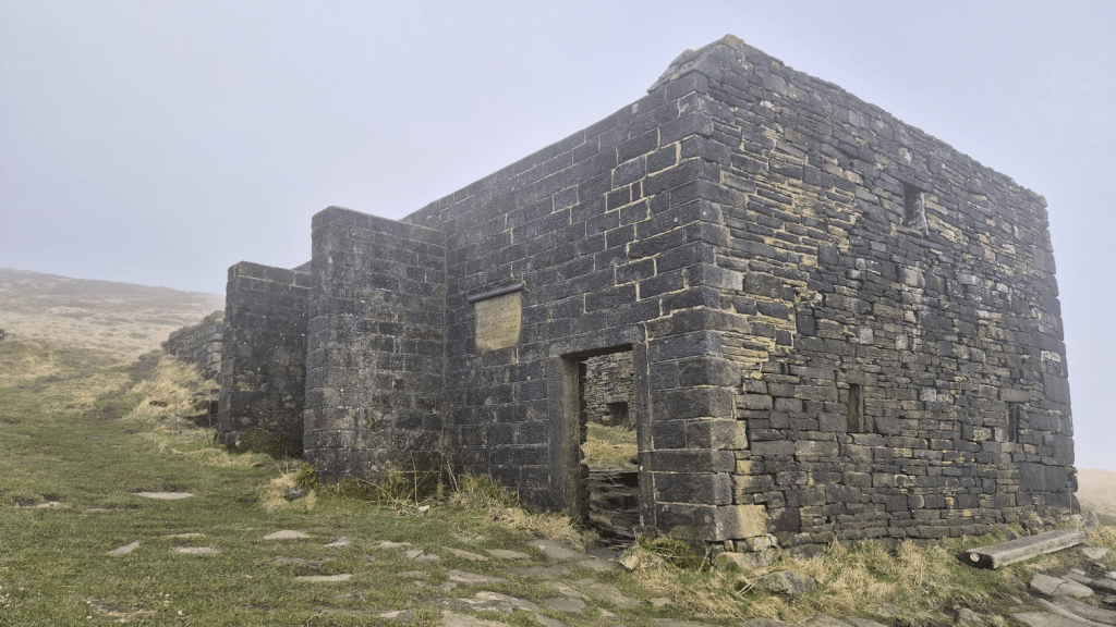
From the reservoirs it is a steady climb to Top Withens. For a building that definitely wasn’t the inspiration for Wuthering Heights, it attracts a lot of attention from Bronte fans. However at 5am in the morning in January it was entirely the preserve of Spine racers. As it was dark, I didn’t take a picture, however as I’ve written a lot of words with nothing to illustrate them with, here is a picture of Top Withens taken on the 2025 Haworth Hobble.
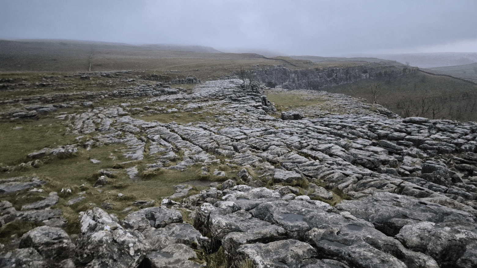
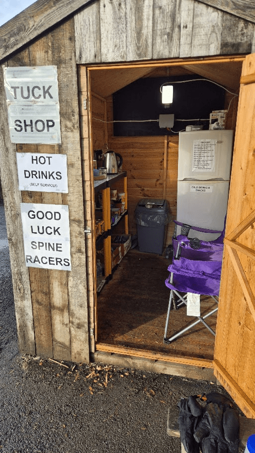
I wasn’t looking forward to Ickornshaw Moor. Last time I crossed it in 2024 on the Summer Spine Challenger South it was a boggy mess and hard to keep to the path. The only saving grace was the previously mentioned Gary Chapman was there with the Craven Energy Tri Club, who had a pop-up feed station providing coffee and bacon sandwiches (other food and beverages were available) to all Spine competitors. On the Winter 2024 edition the feed station was at the Hare and Hounds in Lothersdale but this time my first chance at getting food other than that which I was carrying would be the Cam End tuckshop – about which, more later.
Strangely in Winter the moor seemed easier. The vegetation was less dense so spotting the path was easier, and it didn’t seem any boggier than it had been in Summer 2024.
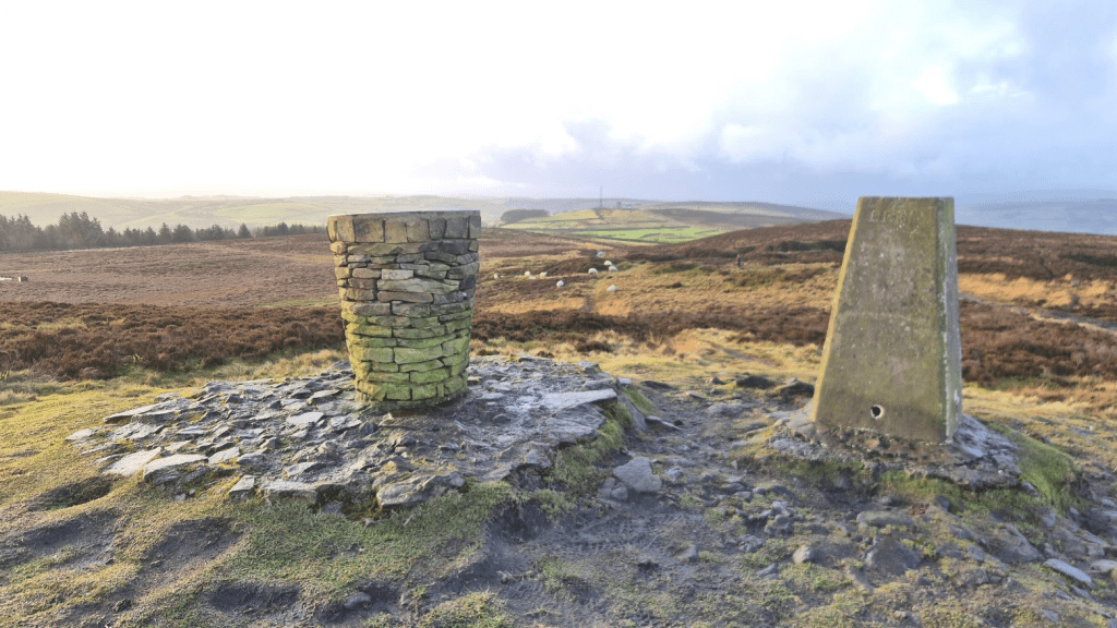
Buoyed by the ‘not as awful as I feared’ crossing of Ickornshaw Moor I continued to Pinhaw Beacon, where I took a picture because, well, why not?
The descent from Pinhaw Beacon leads to a road. On that road I met Hannah (I think) who was out supporting Spine Racers. She gave me a veggie burrito which made up (almost, bacon is bacon) for the lack of bacon sandwich at Lothersdale.
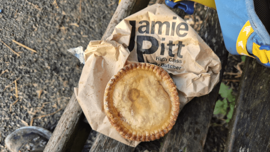
After some more moor (some of it slabbed) it mainly seemed to be fields until Thornton In Craven, from where it was a trek along roads until I reached my favourite place on this leg, the Cam End Tuckshop. Many will point to the Co-Op at Gargrave as being the refuelling stop on this leg – and it has a good case – but for me it’s the Cam end Tuckshop. Why? Well because that is where I first found Jamie Pitt’s pork pies. sorry if you are a vegetarian or vegan but for me a Jamie Pitt pork pie is a bit of Heaven on earth. A pork pie and a bottle of Coke and I was ready for anything – hopefully.
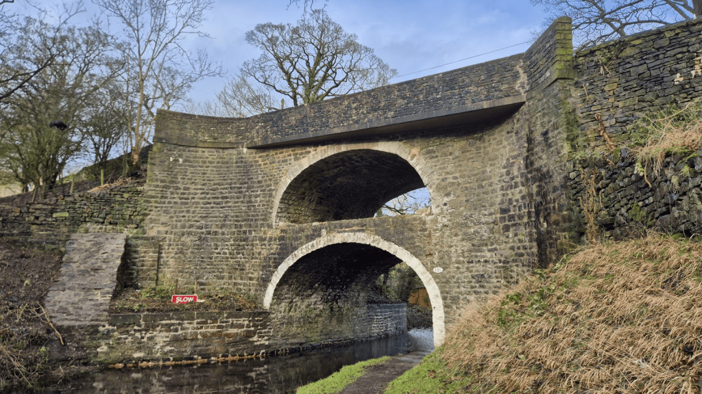
From the Cam End Tuckshop to Gargrave is a fairly unusual section of the Pennine Way in that it is fairly flat. For about three quarters of a mile it follows the Leeds and Liverpool Canal and passed through the double arch bridge at East Marton. Historic England suggests that an original packhorse bridge was built in circa 1790 by Robert Whitworth, engineer and the second arch added to make the passage of traffic over it easier. My only issue with that explanation is that the whole bridge appears to be of a similar age, and I’m not sure how it made the passage of traffic easier, unless there was a drop down to the original bridge. My theory would be that the bridge needs to be that high to align with the road, and that the builders simply built two bridges of a style they were comfortable with, one on top of the other. If they had filled in the top arch it would place a lot of stress on the lower bridge, and one high arch would require engineering and building techniques they may not be familiar with.
Anyway enough speculating about the bridge. I was cheered on by a mountain biker on the tow path before I left the canal for a couple of miles of field crossing to get to Gargrave. In 2024 this section had been diverted via Newton Beck, which made it a very long and tedious road section, so I was pleased we were on the actual Pennine Way this time.
I only paused in Gargrave for long enough to finish my bottle of Coke and say hello to the safety team there. On my way out of Gargrave I saw a woman walking her dog. She looked familiar so I said hello and asked if we had met before. She didn’t remember me but said it was a regular dog walking route of hers so if I had been there before it was possible. We had a very nice conversation and she was very polite, however if she didn’t already think all Spine runners were as mad a box of frogs, she almost certainly does now.
At this point the Pennine Way is following the Airedale Way and after a couple of miles I was following the River Aire. Could have been worse, it could lead to a pack of large terriers.
At Airton the Pennine Way crosses a road. On the road with their car were Jan and Ian, a lovely couple who just like to support the runners and offer them tea and small snacks. We had a very nice chat, I had some tea and continued on. They obviously liked me as they followed my dot to the end and sent me a TrailMail message.
I know the Spine Race is supposed to be a tough, self-supported race, and it is, mostly. There are some, I’m sure, that would argue Nicky’s Food Bar, the Co-Op at Gargrave and especially all the private individuals, like Hannah, like Jan and Ian, and like more I was yet to meet, should be banned and we should only be allowed what we carry and what we get from official water stations. I get that. I did the T184 (184 miles non-stop from the Thames Barrier to the source) and that was exactly like that, I was allowed to collect water from public taps and checkpoints, and that was it, no purchasing of food, no accepting anything from members of the public. It does mean the race is truly self-supported and it means that the playing field is level in that no-one gains an advantage by being fortunate enough to be at a pub or shop when it is open, as opposed to 2am say. However…
How many other events inspire people to want to go out and support, to keep their cafes open 24 hours a day while runners are coming through, to hand out drinks and snacks to people they have never met and yet many of them want nothing in return? For me that is one of the things that makes the Spine Race something else, something extraordinary, and I for one would be sad to lose that aspect of the race.
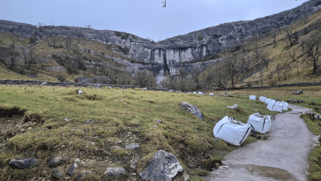
Anyway, by now I was in Malham and heading for the Cove. We had been told there was a diversion in place at the Cove as the limestone pavement was icy and we would avoid it on a more Northerly path. Now it may simply be a sampling anomaly, but if you look at the tracking for some of the elite athletes in the past, not all of them appear to cross the pavement anyway, some do, some don’t, as I said it may just be down to the sample frequency. Regardless of what may or may not have been done in the past, this year we were officially allowed to take a more Northerly route and avoid the pavement.

As is traditional, at the point where the Airedale Way and the Pennine Way part company for a while, I go the wrong side of a wall and climb a fence and a stile to get back onto the Pennine Way – you’d think I’d learn…
Eventually I was at the field centre at Malham Tarn. I’d brought a freeze dried meal with me for just this point. As Malham Tarn is an official monitoring point I knew hot water would be available. One recommendation if you follow this strategy is that you really should check how much water needs to be added and not simply hand the meal to a volunteer and expect them to work it out.
A couple of interesting things were revealed at CP1.5. Firstly we wouldn’t be going over Pen-y-Ghent. Although the wind may not have been as high as it had been, it was decided that since the front runners hadn’t had to do Pen-y-Ghent it would be unfair to make those of us further back do it. The second piece of news, revealed by Gary Chapman, who had moved up from CP1 to volunteer at CP1.5, was that there was the possibility of some hospitality at the Crown in Horton in Ribblesdale. My immediate question was ‘Has it changed hands?’ to which the answer was ‘Yes’. We had stayed there for a recce a couple of years before and let’s just say the couple running it were not particularly interested in supporting the Spine Race. However the new owner had been told about it and was very keen to supply food and drink to passing Spine racers. This was great news but, even though Pen-y-Ghent was out of play, there was the ‘small’ matter of Fountains Fell before I got to Horton in Ribblesdale.
Pen-y-Ghent is 694m high and the Pennine Way passes right over it. Fountains Fell is 668m high and the Pennine Way doesn’t quite make the peak, but tops out at about 660m. However the reason you can go over Fountains Fell in a gale and not over Pen-y-Ghent is more down to terrain than 34m. Fountains Fell is, well, a fell. A fell generally refers to a barren area of moorland. Pen-y-Ghent is a mountain, more importantly it is a mountain that requires a small amount of scrambling to get to the top. It’s something you could fall off and hurt yourself quite badly. On Fountains Fell you could fall over but, generally, you’d be unlikely to fall very far. Hence Fountains Fell in high wind is unpleasant whereas Pen-y-Ghent is dangerous.
My navigation to Fountains Fell was fairly good, although I did get caught out by a heavily camouflaged stile. The gate in the wall was clearly locked so I assumed the path continued to follow the wall. When my GPS indicated I was off track I returned to look more closely at the gate, definitely locked. However next to it were some stones sticking out of the wall which form a kind of staircase so you can cross the wall. There are various techniques employed by stone wall builders to allow people to cross the wall. All of these indicate that the wall builders hate people and that they particularly hate those that would dare to cross their wall. At ground level its usually a gap barely wide enough to get your leg through. This will often be backed up by a gate with a spring you could launch satellites with. The step stile has been mentioned but a particularly amusing variation combines the two – you are invited to climb up onto the wall and manoeuvre through a small gap, over which there will be a gate with a spring that could hold the gates of Hell firmly shut. If you are very lucky you will make it over without either being trapped in the gate or propelled half way across the next field.
Anyway shortly after the stile incident (and some more stiles), the Pennine Way crosses a small road. There was a car on the road. When it stopped I assumed it was a Safety Team but no, it was simply a local (I assume) who wanted to tell me what a great job I was doing. I guess he was going along the road anyway and saw my head torch but see my previous ramble about the effect this race has on people.
Once I was over Fountains Fell things got really interesting. Going up there hadn’t been a great deal of snow and ice. That was because it was all waiting on the other side. the mile or so down presented far more challenges than the four miles of up since Malham Tarn, and so I was very pleased to see the road to Pen-y-Ghent.
Despite the fact I wouldn’t be summiting Pen-y-Ghent, I would still climb some way up it before turning off to Horton in Ribblesdale. The diversion was interesting. Much of it was very ‘built’. There were steps, slabs, a smooth obvious path. And then at some points it just disappeared into rocks and you kind of had to work out your own way round until it became a path again. Or I was lost – that is possible.
Anyway I arrived in Horton in Ribblesdale and was met by a safety team who guided a small group of us to the Crown, where the passive-aggressive notes defining what was and wasn’t allowed in the bar had been replaced by a welcoming host who provided coffee and vegetable soup. This is a definite upgrade and I’m fully intending to return and stay as there is some great running in the area – the Yorkshire Three Peaks for a start.
Unfortunately I had to leave the pub to start my inexorable journey to the darkest, most dismal, soul destroying, morale sapping section of the entire Pennine Way – the Cam High Road.
There’s nothing much to say really, it was tedious, there was snow and ice in places and along the side of Dodd Fell there was a howling gale blowing across me. I was looking forward to getting to Ten End, as Gaudy Lane would put the wind slightly more behind me and hopefully it would drop as I went down towards the appropriately named Gayle.
The descent was horrific. There was no ice, just mud, slippy, slidey mud. I fell more than once, coating myself and my pack in mud. It seemed unending, I just wanted something under my feet that was fairly solid and didn’t smell bad. I knew that eventually I would hit a solid track so it was a case of slipping and sliding down the hillside until that point.
The last mile or so always feels a bit like its a long way round when I’m doing it but actually its a fairly direct route into Hawes. I made a small error by the church – I knew I wanted the path to the left but didn’t realise I’d already taken it and started out on a different left, however the GPS track showed me the error of my ways and I was soon back on track and at Checkpoint Two, the YHA at Hawes. I stripped off my mud covered waterproofs and shoes and went in, where I met up with Rachel, who was working at CP2 this year. My plan was to stay for the full eight hours and get some rest…

The race is hard enough as it is, Colin. Why do people want to make it harder by insisting on it being unsupported?
LikeLike