After eating and drinking I followed my normal routine and tried to get some rest. At CP5 the sleeping area was a darkened hall. I took my mat and sleeping bag into the hall and prepared to get some, if not sleep, at least some rest. Someone in the hall was snoring very loudly. As I laid down my last thoughts were ‘I’ll never get any sleep with that rac…..’
I awoke to my alarm and packed up my things for the last time. Previously I had tried to put things back into my drop bag in some sort of order but this time it really didn’t matter – I wasn’t planning on opening it again before I was back home in Essex. Last breakfast (porridge, I think), last coffee, last kit check and, at 2:30 on Friday morning, I set out into the unknown.
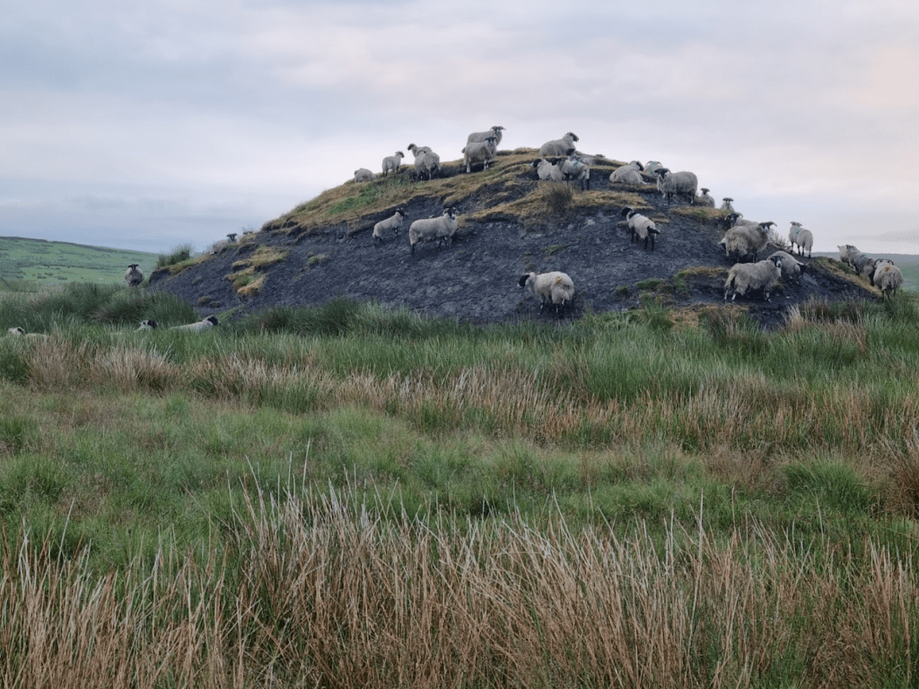
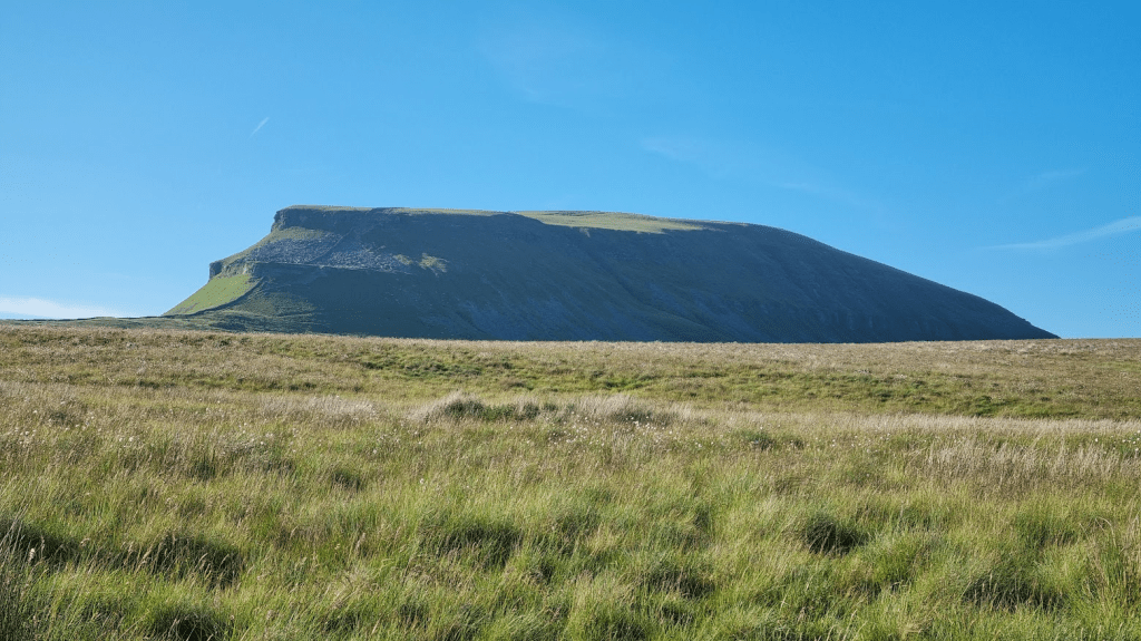
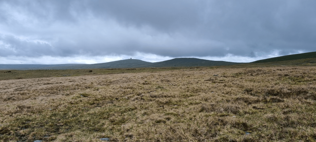
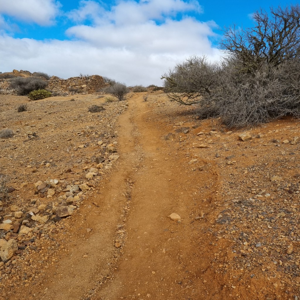
The first mile and a half presented a slight navigational challenge as I was walking through Bellingham. It wasn’t difficult but I had to keep a careful eye on my GPS to avoid taking the wrong road. Eventually I left Bellingham and turned on to the kind of moorland I was expecting. The path was still fairly dry, even if the sheep were taking no chances and appeared to be crowded on the higher ground.
The sheep seemed to prefer the high ground
I was only a couple of hours into the final leg and already I knew it was going to be a long day. By the time I reached Hareshaw House, about four miles in, the trail crossed a tarmac drive. I took the opportunity to put my pack down and lay down on the road to try and stretch my back, a manoeuvre I would be repeating throughout the last leg.
I didn’t really have much idea what to expect from the final leg of the Spine Race. I knew a short section of the Pennine Way around the Cheviot from having done the Cheviot Goat Race earlier in the year but the section from CP5 to CP5.5 was completely unknown. My hope was that it would be reasonably straightforward. My hope wasn’t completely in vain. Sections through heather were a little awkward simply due to the path being a narrow groove obscured by vegetation. Eventually I started to enter Redesdale Forest and back to my favourite scenery – not – plantations!
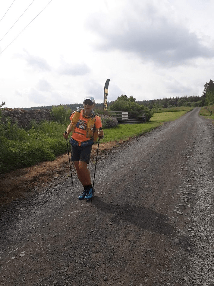
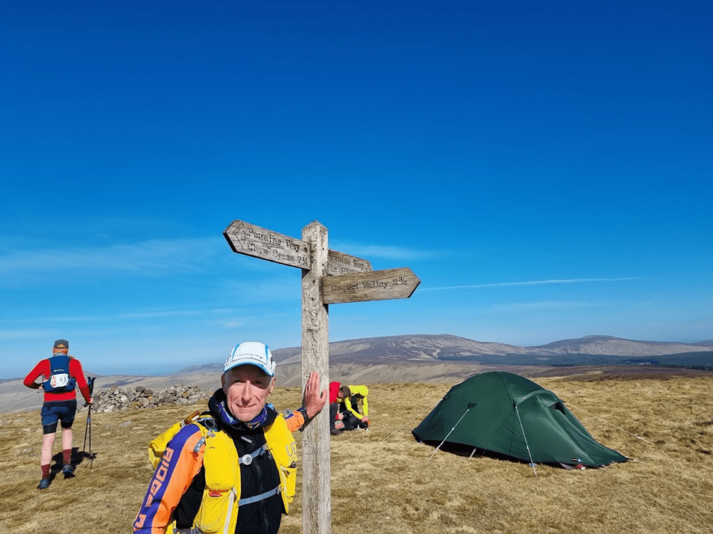
After seemingly endless plantation roads I eventually arrived at CP5.5 at Blakehopeburnhaugh. By now I was leaning heavily and in quite a bit of discomfort. However this was another one of those occasions when the volunteers and marshals would work their magic and keep me going. John Bamber shared all his knowledge of back stretching gained from his own back problems, the medic (sorry, I never got her name) asked what pain relief I had taken and deemed it safe to give me another codeine tablet. One of the other volunteers (again, I didn’t get a name – sorry) lived in the area and was able give me a good impression of what my next task would be like – the ascent of Byrness Hill. I ate most of my freeze dried meal, had a couple of cups of coffee and prepared to set off. The checkpoint had a board showing me exactly what I had left to do: 10 miles to Hut One, 9 miles to Hut Two, 7 miles to Kirk Yetholm, about a marathon left in total.
Sometimes, when things are tough, someone says or does just the right thing to give you the self belief you need. As I left CP5.5 John Bamber walked out with me, clapped me on the shoulder, shook my hand, and said he was proud of me. I already knew I wasn’t going to give up but at that moment the thought of failure became impossible.
Leaving CP5.5
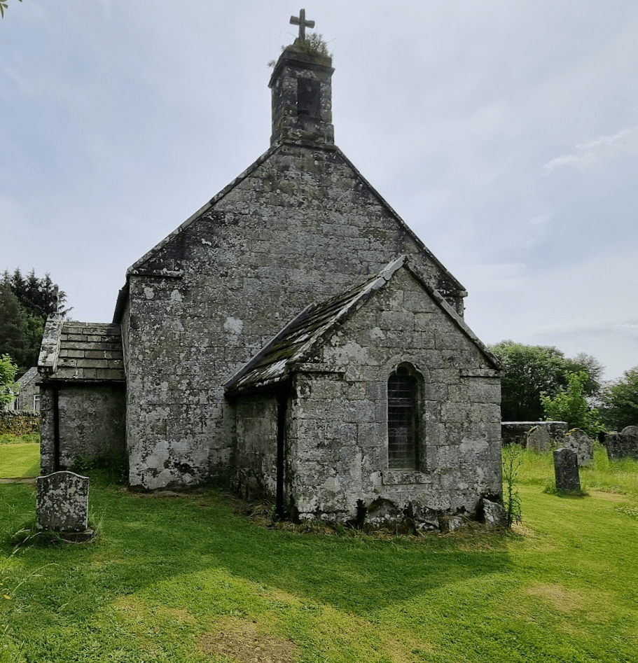
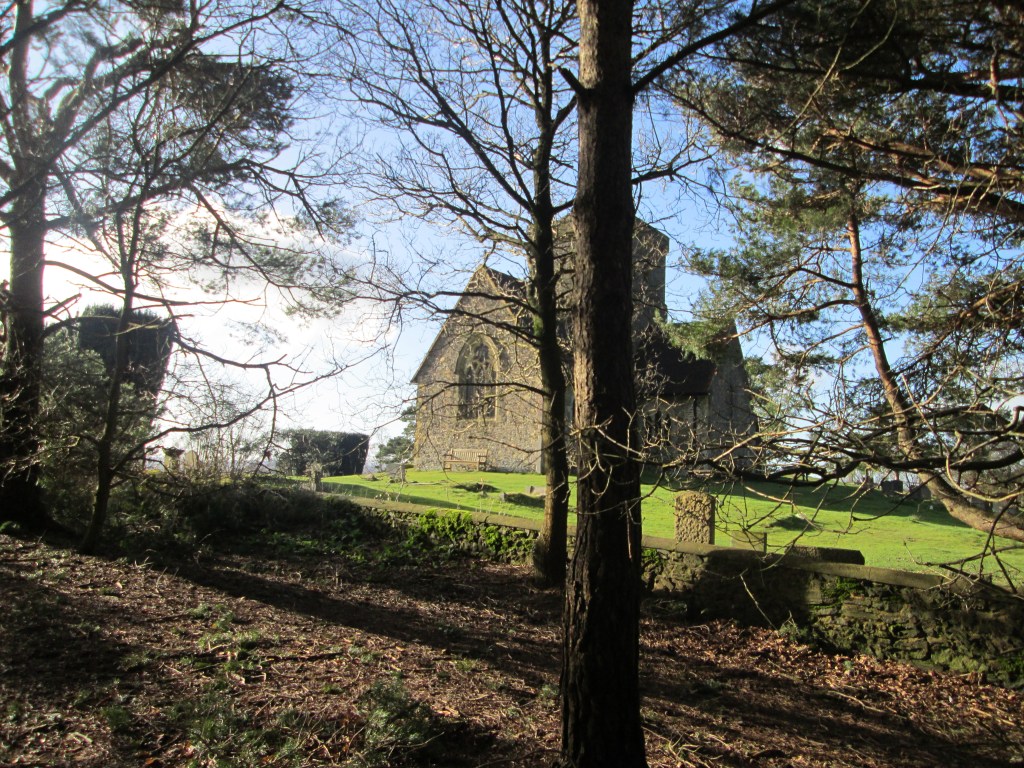
A couple of miles further down the road I arrived in Byrness. I had been given a good idea of what to expect Byrness Hill to be like, a sharp climb requiring some use of hands to get round some rocks near the top. I noticed a small church with a bench in Byrness and decided to have a look in the churchyard (I like that sort of thing) and to use the bench to stretch out a bit. The bench had a plaque. I don’t remember the name of the person in who’s honour it had been placed but I felt that if he was the sort of man who’s passing his friends would mark by placing a bench in his memory, he was probably the sort of man that wouldn’t mind me using it to try and prepare myself for the next stage of my journey.
Byrness Church
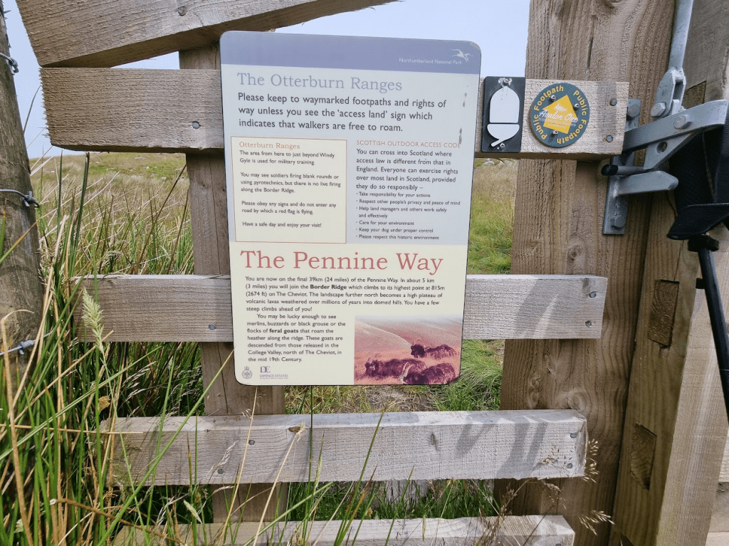
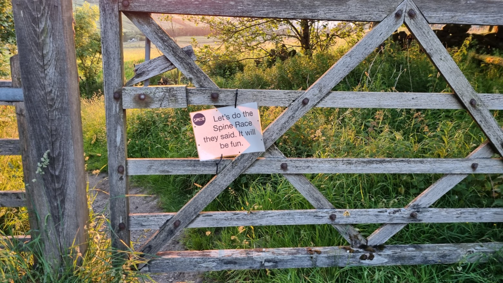
Byrness Hill didn’t prove too much of a challenge as it was quite dry. I suspect it is quite a different story in the winter. I passed through a gate which had a lot of interesting information on it. I was too far gone to really understand any of it – apart from the fact I wasn’t likely to get shot, which was nice, and that there was still 24 miles to go, which wasn’t so nice but not a surprise – so I photographed it to read later.
Lots of interesting information
By now it was getting very hot and sunny. A few runners passed me along the border, although we all seemed to stop at various points and rest. I fell asleep at least once in the sunshine so had little idea who was ahead and who was behind me. To be honest at his point there were few things that mattered less. My immediate focus was simply on putting one foot in front of the other and trying to reach Hut One.
After what seemed like forever Hut One came into view. I was able to lie down on a bench and stretch my back. I wasn’t due any more pharmaceutical pain relief but the medic did offer ‘interpretive dance’ as a service to another runner in the hut at the same time as me and also in pain. I settled for biscuits and coffee.
The weather took a turn for the worse and by the time I was ready to leave the hut it was definitely raining so I put my waterproof on. In some ways I was almost glad the weather had become worse, I now felt I was getting a proper Spine Race experience, even after the rain stopped, the cloud remained and the path ahead started to disappear into the mist.
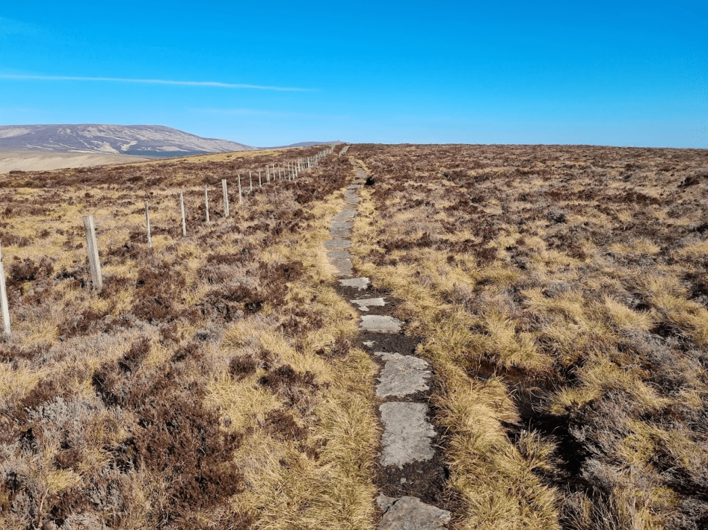
Unfortunately even the worsening weather wasn’t sufficient to take my mind off the worsening pain in my back. I never run with music but I must admit I was now wishing I had something, anything, else to focus on. I possibly should have focussed a little more on where I was as at some point I had ended up in Scotland instead of England. I was on a path and the path followed the border fence, just on the Scottish side. The big difference was that when I looked over the fence, I saw the ‘English’ path had flagstones! Once I was on the paved path I started counting flagstones to take my mind off how slow my progress was. After Windy Gyle the next major point on my journey would be the left turn of the shoulder of the Cheviot down to Hut Two. I didn’t know how far Hut Two was from there – I had made the error of not marking the huts on my GPS files – but I knew it was at least downhill.
As I was slowly making my way down from the Cheviot, I was caught by Andrea. She could see I was in trouble and asked if she could help. I thanked her but said that, no, there wasn’t really anything anyone could do, I’d just got to get on with it. She said in that case she would let them know at the hut that I was in trouble and they would perhaps come and meet me. Then she set off in what to me appeared to be the wrong direction but shortly after I saw her on what I thought was the correct path so either I was wrong (very possibly, I was starting to see things) or she realised her error.
The light was failing and, although I could still see well enough to pick my way down, I thought it might be a good idea to put my head torch on anyway just in case anyone came looking for me. Fatigue and hope lead to me seeing all sorts of lights in the distance, practically none of which existed I’m sure. However after a while the lights were accompanied by voices. My poles and pack were taken from me (I questioned whether someone else could carry my pack but was told it was part of my assessment – this was in fact true, one of the things they wanted to know was how much effect the pack was having on my lean and my back problem) and I was lead the final half a mile or so to Hut Two.
The fact is that every single medic, marshal and volunteer on the Spine Race is an incredible human being who’s main focus is on making sure that everyone that can finish safely does so. However because of that they all seem to be superhuman people that pick you up and set you back ready for the next bit. The idea of DNFing at Hut Two, seven miles from the finish, didn’t bear thinking about. Spine HQ obviously agreed as, knowing that I was struggling, they agreed that I should be held at Hut Two until first light to give my back some rest and to allow the various painkillers I’d taken to work through and let me start again in the morning. I have managed to find out the names of the team at Hut Two so I can give huge thanks to Theo (medic), Alex and John for sorting me out so that I could continue on my way.
Early Saturday morning I was dressed in my waterproofs, warm hat, gloves and mid-layer. This was the first time I’d needed them all but does vindicate the kit list as I did need them all, at least at the start of my final assault on the Pennine Way.
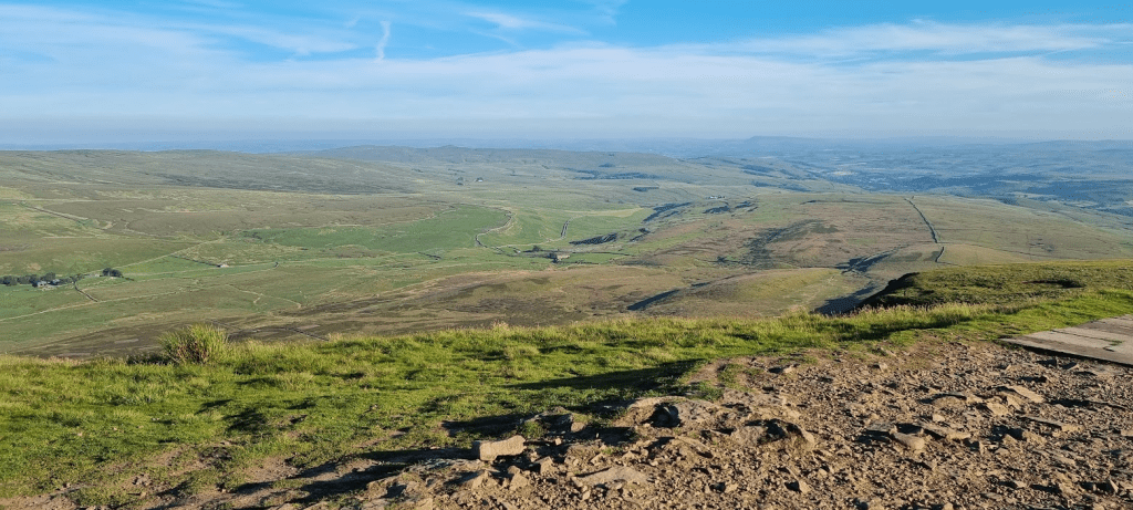
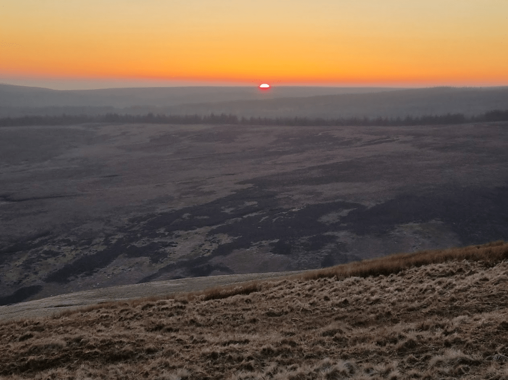
There was only one final obstacle between me and Kirk Yetholm – The Schil. The Schil isn’t a massive hill but it is still a sting in the tail of the Pennine Way. At Hut Two I was told it was a grassy slope up and a slightly steeper rockier slope down. I decided this was probably the way I’d prefer it at this stage. Obviously the Schil was what it was and couldn’t care less what I preferred but it was good to try and be positive. I was rewarded for my early start by a magnificent sunrise. Unfortunately with all my kit on I wasn’t able to take a picture but it lifted my spirits anyway. After a while I’d conquered the Schil and felt confident I would make it to Kirk Yetholm – it was just going to take a long time.
As I was coming down I could see that I would be out of the shadow of the hill and in the sunshine. My watch was complaining it was out of battery, I needed a break and to take some clothes off so I decided that as soon as I hit the sun I would rest for 15 minutes and charge my watch up. I called Spine HQ to let them know. The rules say you don’t have to do this unless you are stopping for more than an hour but I was fairly sure my dot would be being watched very closely, given they knew my physical state, and I didn’t want to give any cause for alarm. They very kindly said if I hadn’t moved after half an hour they would phone me as I would probably have fallen asleep.
After my break I carried on down and reached the Scottish Border! I climbed to the top of the stile and announced ‘I’M IN SCOTLAND!’ as loudly as I could. No one heard apart from the sheep.
The border!
The path became a road and I lay down to stretch my back. A lovely lady in a Landrover carefully drove round me and asked if I as alright. I assured her I was and thanked her for her concern. From here on it was just a case of walking and stretching, my poles slamming into the tarmac with every step. Fortunately I was ready for the hill into Kirk Yetholm so I just marched up it as the village came into view – I didn’t even stop on Anne’s Bench at the top.
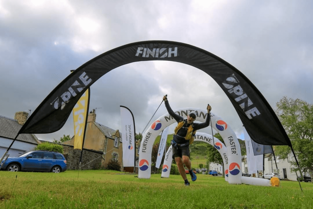
Suddenly I could see the finish! I started to run, well a fast stagger anyway, towards the arches, an untidy mess of flailing limbs, some sort of weird parody of a finish line celebration.
Nearly there….
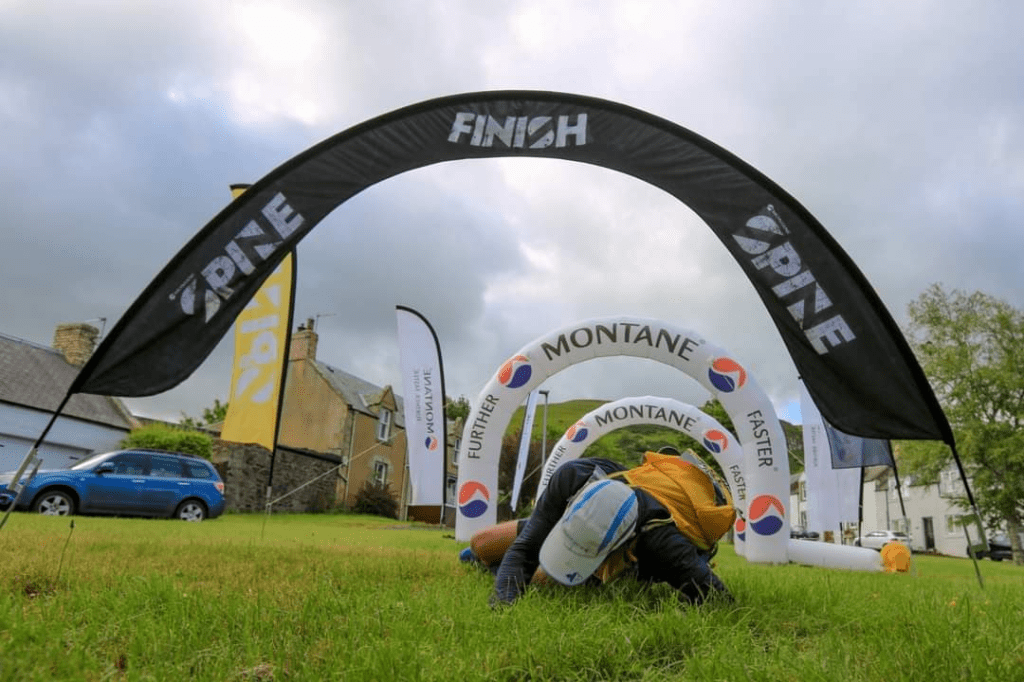
I made it to the arches, tripped, fell, collapsed, I’m not sure which….
…almost all over
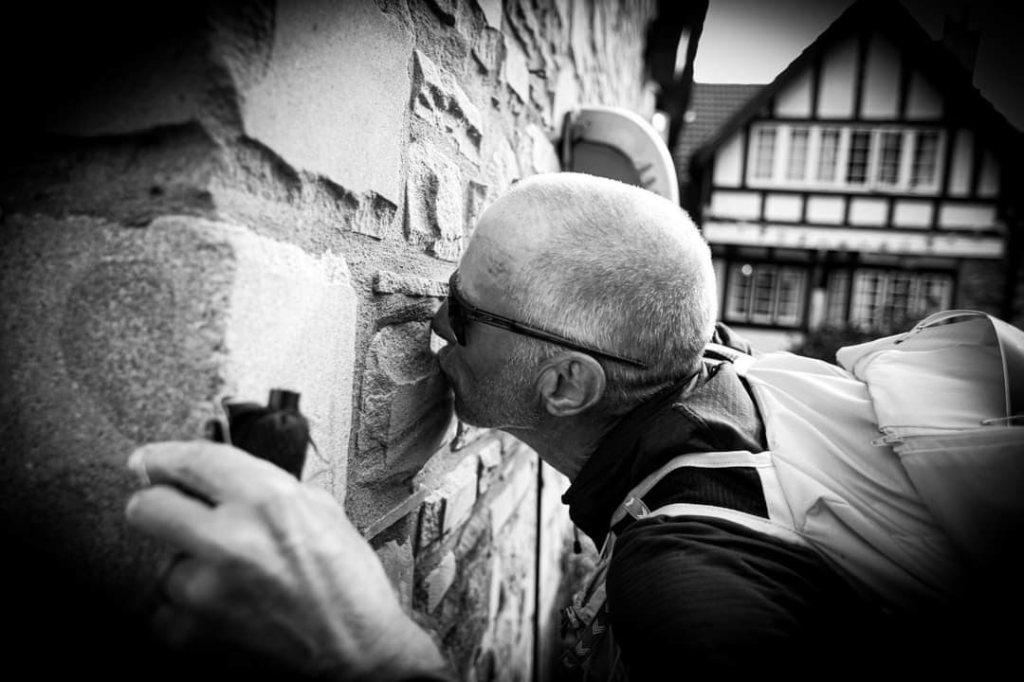
…until Sharon came over and pointed out I had several yards to go to the Border Hotel wall and the real finish. I got up and quickly made my way to the wall and gave it a kiss, and another, just to be sure.
Made it!
There were many volunteers at the finish to cheer me on, who then looked extremely confused by my desperation to get into my backpack. In November last year my Father-in-Law passed away. In his last days he was looked after fantastically well by Marie Curie Nurses and the ACCORD Hospice. I am raising money for both these organisations, if you would like to support me donations can be made at: https://donate.giveasyoulive.com/fundraising/colins-summer-spine-race Archie was a proper Scot who liked a wee dram. I had been carrying a small hip flask of his favourite whisky, Ballantines, from Edale in order to drink a toast to him on the finish line. I also raised a toast to Hut Two and everyone else that had got me to the finish.
Cheers Archie!
So we come to the end of my Pennine Journey. Some of you will have been with me since the beginning a year ago, some will have joined on the way and some will only just have become aware of my endeavour. The question is – is that it? Well, in one way yes, I set out to use what I learned from last year and to complete the Summer spine Race 2022 and that I have done. Will I ever do a Spine Race again? I think many of you will realise having read my blogs, I don’t rate the Pennine Way as a particularly wonderful path to follow. It has amazing highs and some fairly dismal lows. However the thing that might bring me back is the Spine atmosphere, it’s very hard to describe but an often used phrase in the Official Spine Facebook Group is ‘Those that know, know’. I’ve always said I would never do the Winter Spine. Having done the Summer Spine I’m fairly sure I couldn’t do the Winter Spine. However 2023 is sold out anyway but 2024? Maybe…
All that is left to do is to thank everyone involved in my Pennine Journey. All the Spine organisers, volunteers, marshals, medics, safety teams, all my fellow competitors and of course all of you that followed my dot, sent me a message, sponsored me, or just wished me well, thank you all. The final and biggest thank-you has to be reserved for Sharon though, from picking up a stinking mess at the end of last years race to being there at the finish of this years, without her constant and unwavering support there would have been no ‘Pennine Journey’ – Thank you and I love you forever x
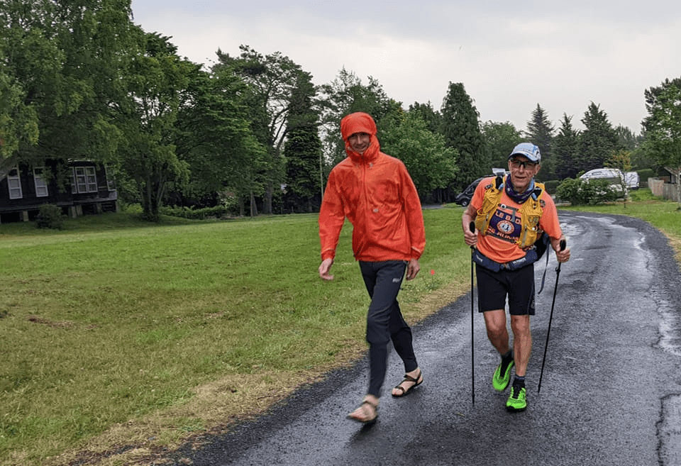
Before I left CP4 the feeling of deja vu overtook me again – here I was, having my feet taped while Rachel brought me breakfast. However this time the taping was much less extensive than last year and some of it was simply preventative to protect some hot spots that were developing. One kit check and a hug from Rachel later and I was off to do what I hadn’t managed last year, get to Checkpoint Five.
There is little to say about the route from Alston, the Pennine Way climbs a little out of the river valley before bowing to the inevitable and going back down into it. Not long after leaving the checkpoint I was caught by Gerry, Wijnand (a Dutch runner Gerry had teamed up with sometime before and who came into CP4 with us – he just walked a little ahead of us as I assume he wasn’t interested in phone boxes) and another runner whose name eludes me. I stuck with them until Slaggyford but they were setting a faster pace than I was really comfortable with so I let them go. Sadly we arrived at Slaggyford in the early hours of the morning and so the Angel was in bed.
Hartleyburn Common South Side was fairly easily navigated apart from the very last section to the A689 crossing. It’s not that it is hard to navigate, there just is clearly no path exactly where the Pennine Way is supposed to go – I just followed the GPS and bashed my way through the heather anyway, eventually there will be a path. I met a marshal at the road crossing who was leaving snacks and water for Spine runners, he agreed that I had quite definitely not followed any sort of visible path. I took a bottle of water and a chocolate biscuit and continued.
Last year I got hopelessly confused trying to cross the Black Burn and ended up climbing a barbed wire fence, crossing on a derelict bridge and then climbing a dry stone wall to get back on course. It was much easier in the daylight with at least 50% of my faculties working.
Last year in the dark I missed this and climbed over to the derelict bridge in the background
At the road crossing at Greenriggs I met a member of the media team who asked about my lean. I made a joke that I wasn’t turning into Jeremy Corbyn but I had developed a strong lean to the left and that the medics had decided I was fit to continue but just a bit weird. I hadn’t immediately realised I was actually being videoed and that my weak jokes would make it into the Day 6 round-up… (https://www.facebook.com/TheSpineRace/videos/427118255950339 about 2:45 in if you are interested).
After my brush with fame I continued on to Hartleyburn Common North Side. I didn’t seem to be able to find the exact path across it as I did when I recced it but as it was fairly dry I concentrated on making progress in the right direction rather than worry too much about my exact route. Soon I was rewarded with my first sight of Blenkinsopp Common
Blenkinsopp common – something to pass through rather than visit in my opinion
Fortunately Blenkinsopp was more Common than Bog and the path across it fairly easy to follow. After the Common there were cows. Just before the safety of the track to the A69 there was a bull – with a cow to impress. I tried to look uninteresting, hide up a bank and generally behave like a complete wuss until I could make a break for the gate. As I was walking towards the A69 I met Gerry and Wijnand coming towards me, convinced they were going the wrong way. They weren’t but I could understand their confusion. I remembered from my recce that one of the gates appeared to secured with a bicycle lock and had no signs to indicate it was on the Pennine Way. In fact the lock could be lifted over the post and the gate opened and a few yards further on was a post with the acorn symbol denoting a National Trail, but it wasn’t obvious. After the A69 it’s down to the golf course and exit via a very overgrown path to cross the B6318.
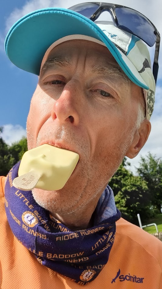
At Thirlwall Castle the Pennine Way starts to follow Hadrians Wall. A short climb saw us arrive at Walltown Quarry car park at two minutes to ten, perfect time as the café opens at 10! I had a coffee, ice cream and chocolate.
Perfect timing
Yum!
I intended to do another Facebook Live piece from Hadrian’s Wall but a patchy data signal meant the video kept stopping and restarting so I gave up and carried on running instead. I say running, by now I was rarely getting much above a fast walk. It was also getting very warm and – as far as I knew – there were no more water stops en-route. The next 8 miles would follow Hadrian’s Wall and were very up and down.
Quite glad this didn’t keep the Scots out or I would never have met Sharon!
Last year I was in a world of pain along the Wall and so possibly didn’t realise just how long it went on for. The weather was great but I was getting a little worried about whether I would have enough water. I did remember last year I was taken to a snack van in the car park at Steel Rigg by a safety team while they assessed my fitness to continue. I thought it worth the short detour to see if there was anything there – there wasn’t. Just when I was thinking of offering anyone in the car park large sums of money in return for water, I saw a Spine Safety Team (Five, I think) in the car park with water. I was grateful for the sit-down, the chat and, of course, the water. I was less happy about the picture Gill took of me – I look like E.T.s Grandad!
Disturbing!
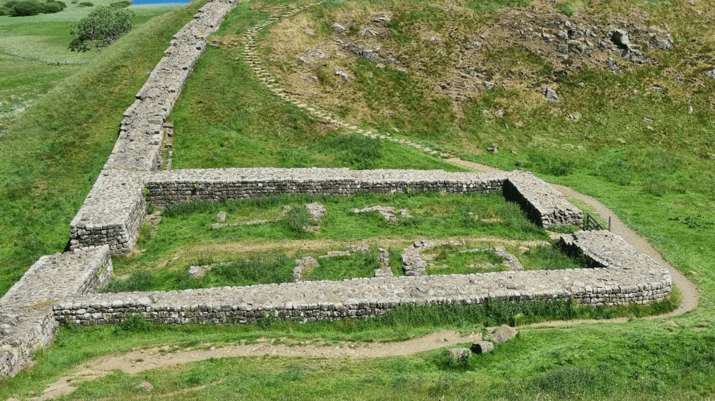
Shortly after Steel Riggs I saw the remains of a Mile Castle. According to the OS map there are many features along the Wall but when you are doing the Spine Race unless you actually have to walk round it – like Mile Castle 39 – you are inclined to miss them, well, I certainly was anyway.
Mile Castle 39 – I think it was also labelled Nick’s Castle
Eventually it was time to leave Hadrian’s Wall and head towards Wark Forest. The Pennine Way follows its own path through the forest and last year proved quite boggy. Due to damage still remaining from Storm Arwen, this year we were diverted and stayed on forestry roads. These were dry, hot and seemingly always uphill. I started to take a strong dislike to ‘forestry’ as I walked through the plantations. It wasn’t helped by the fact my back was starting to hurt and I was having to stretch at regular intervals. I like forests, they have undergrowth, birds, animals, an entire bio-diverse eco-system lives in them. Forestry is battery farming for trees. Non-native spruce planted so close together nothing can exist in the forest just to ensure the trees grow straight. When they are ready for harvesting they are ripped down with chainsaws and piled on lorries leaving huge grey scars on the countryside.
Nothing lives in there
After a few hours of walking past unnatural forests and devastated hillsides I was quite angry about the whole thing. Fortunately I would soon reach a point which would reaffirm my faith inthe human race – the wonderfully named Horneystead Farm.
This is the kind of thing you want to see on the Spine Race!
I followed the signs and was greeted by a lovely lady who gave me a ham roll, some cake, a can of Fanta and a cup of tea! I have been told she is an ultra runner and makes her barn available to runners with a stock of food and drink on both the Summer and Winter Spine Races. She doesn’t charge but will accept donations. I’d accumulated a fair bit of change by this point so I was happy to donate some pounds and slightly reduce the weight I was carrying!
Horneystead Farm
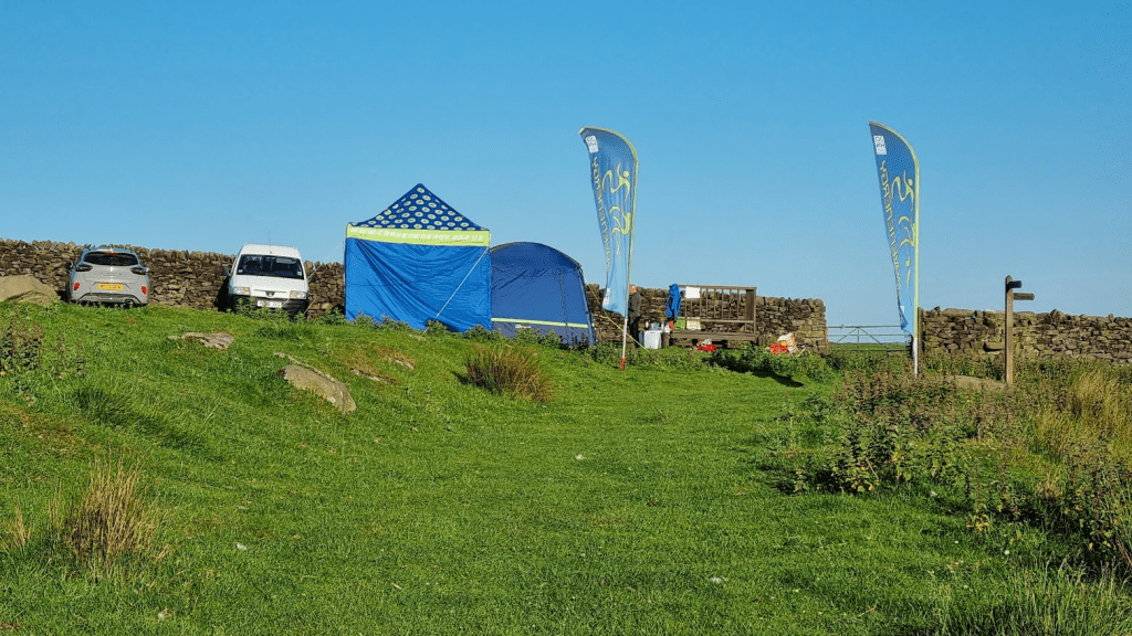
Finally it was time to move into uncharted territory – once I passed Shitlington Crags I would have got further than I managed last year. Then it was uphill, past the tower and across the fields and finally along the road to Brown Rigg and Checkpoint Five. As I started up towards the tower it started to rain, however as I was already wet with sweat and it wasn’t cold I pushed on and was met by a marshal (in waterproofs) at the entrance to the camp site.
Leaning into CP5
I had made it to CP5! As always I was incredibly well looked after. I drank a couple of pints of squash and tea as I had got a little dehydrated in the afternoon heat. I was given two bowls of the most amazing sausage casserole and even had someone picking up things off the floor for me as I had been made to sit with my leg up as my right knee tendon had swollen again. After a while I went into the sleeping area for a couple of hours rest before I would set off on the last leg of the 2022 Summer Spine Race…
My alarm woke me after about two hours of sleep in total confusion. I think my conversation with Lindley had affected my dreams as I awoke convinced I was in the middle of my kit check. I packed my stuff up and went back to the main room to hunt down breakfast and get some attention for my feet. Generally they weren’t too bad but I hadn’t managed to get rid of a callus on my left heel before the race and it had blistered. I’d started off taping it myself but as the race went on it became harder to bend myself round to tape my own heel so at CP2 I’d asked a medic to do it and was hoping for a repeat at CP3.
I did get my feet taped but it was a bit tight on timing. The pre-race briefing tells you not to rely on medics for foot taping as they may have more serious emergencies to deal with. As I was waiting, Sabrina and Raj arrived. I didn’t get to see them as Sabrina did require the attention of one of the medics. Fortunately she was OK and, although I wouldn’t cross paths with them again, both she and Raj would finish. As it was I just got my feet taped and kit check done before my 6 hours were up.
CP3 to CP4 – Middleton to Alston – really is a leg of two halves. It starts of with the Tees and the waterfalls thereon. It continues with High Cup Nick and drops down into Dufton with its promise of places to eat and drink. However it then has the tough slog up to Green Fell (or is it Knock Fell? I’ve never been sure) and the run over Great Dun Fell, Little Dun Fell and finally the notorious Cross Fell. After all that there is still 11 miles to go before arriving in Alston.
Anyway I’m getting ahead of myself. Last year I left CP3 at sometime on a sunny afternoon and was sharing the path with numerous tourists, at about quarter past four in the morning it was a lot quieter!
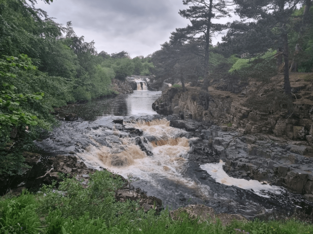
Teesdale Low Force
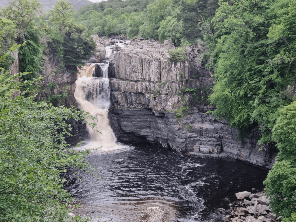
It was a very pleasant early morning saunter along the Tees from Low Force to High Force.
Teesdale High Force
After High Force it was fairly easy going until the scramble over various boulders – which may or may not be Falcon Clints, I’m not sure. I did however forget to photograph them as I was using all my concentration just to find a way through. I can only assume that when the likes of John Kelly and Damien Hall set FKTs on the Pennine Way they must have their route though the boulders memorised – I certainly didn’t remember how I did it last year but I think I was a little better this time.
It’s not all waterfalls…
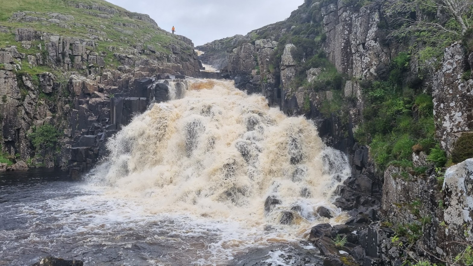
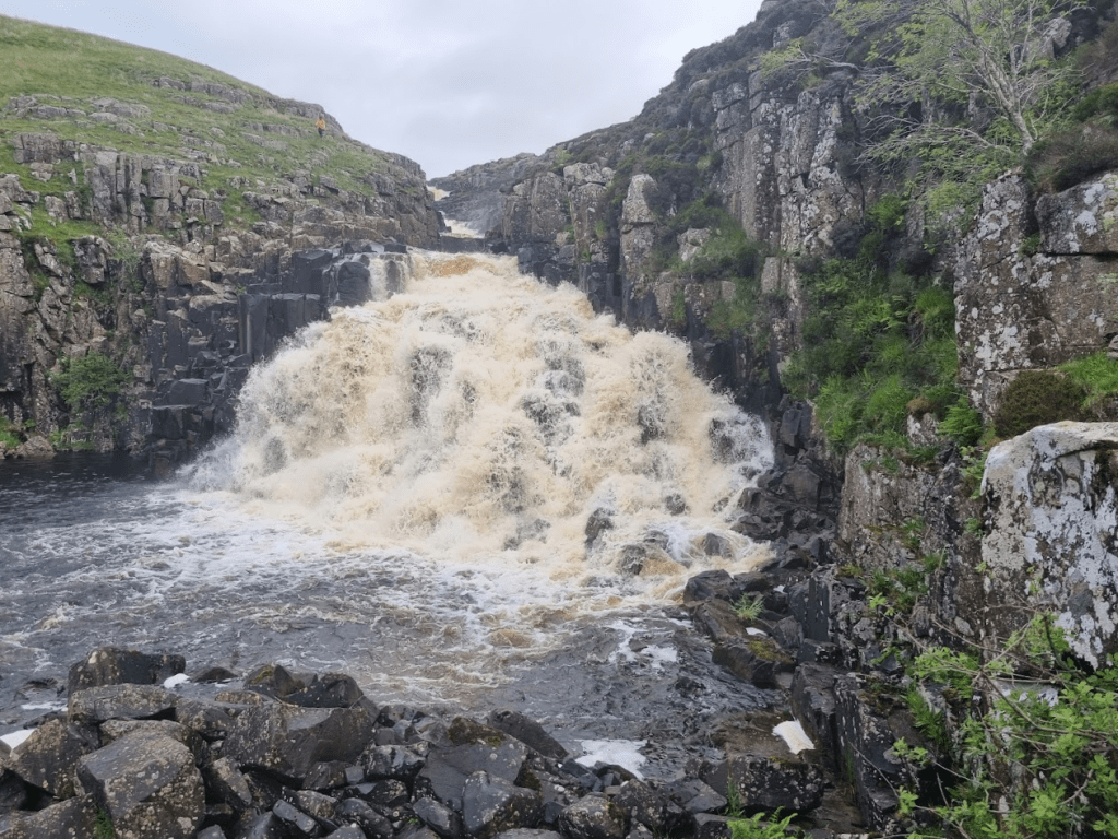
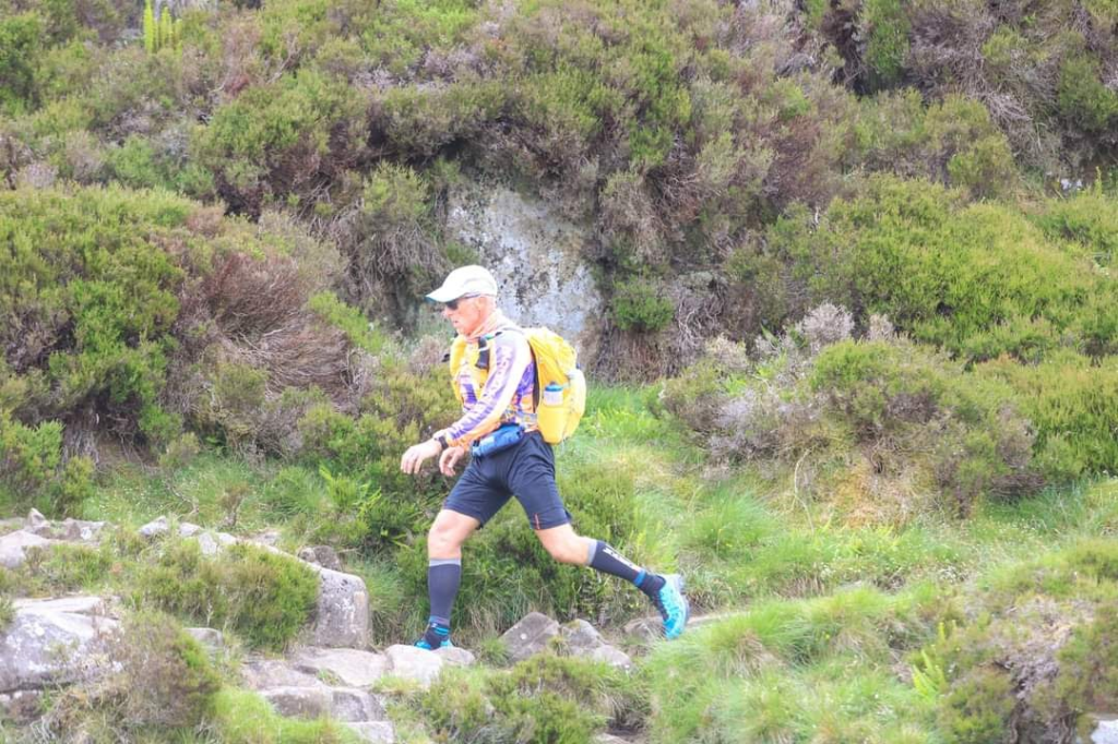
Eventually I reached Cauldron Snout. The scramble up the side is quite easy – in summer at least – as you are some distance from the actual water. Adam, one of the photographers is the small figure in orange and was documenting my ungainly ascent.
…but here’s another – Cauldron Snout, I have to scramble up the right hand side and leave the Tees at this point
On my way up Cauldron Snout
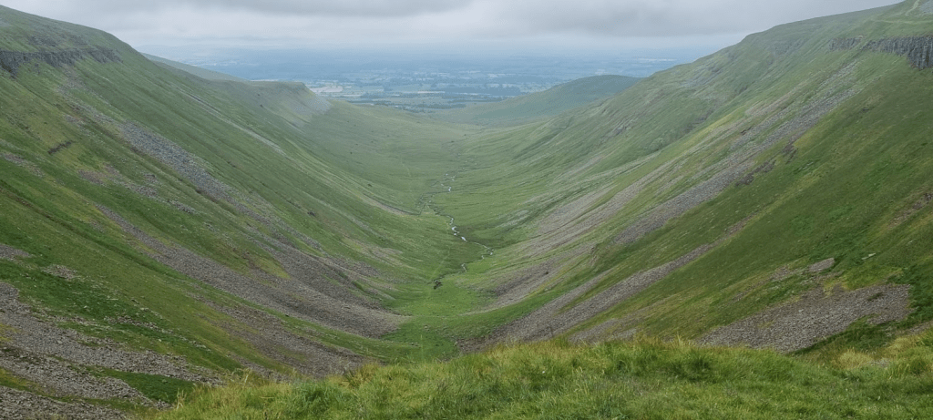
After the scramble it was about 5 miles across Dufton Fell to one of the highlights of the Pennine Way – High Cup Nick. Sadly I knew I wouldn’t be seeing it at its best due to the low cloud but it was still worth a picture.
High Cup Nick
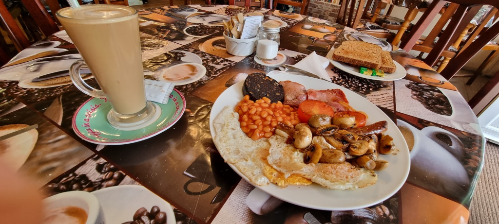
Shortly after leaving High Cup Nick I found a sheltered area where I stopped for a short rest and to give a quick live update to anyone listening. Soon after I met some hikers who informed me they had seen people eating breakfast in Dufton. That was all the incentive I needed to get down ASAP!
As I came to the centre of Dufton I was met by a lovely marshal who asked what I needed. ‘Breakfast’ was the answer so she ordered me a full English and a latte from the Post Box Pantry – which turned out to be quite possibly the finest full English on the Pennine Way!
No words can describe how much I enjoyed this
Properly fuelled I was ready to tackle the hardest part of the challenge so far, Cross Fell. I had recced this section recently, which makes it even more annoying that I was seduced off course by the very big and obvious stile that isn’t on the Pennine Way… Anyway I was soon on the right route and slowly ascending to Green (or Knock) Fell.
Great Dun Fell’s giant golf ball
There isn’t really a lot to see up on the fells. The giant golf ball antenna thing on Great Dun Fell is the most significant thing and to be fair it is quite significant. As an electronic engineer I should probably find it quite interesting, as a Spine racer I was just happy to have it behind me.
Little Dun Fell
Soon I reached Little Dun Fell and the patch of scree that caused me to lose all my confidence last year. Having recced it and it being daylight this time, I crossed it without incident and headed to the final climb to Cross Fell.
Cross Fell
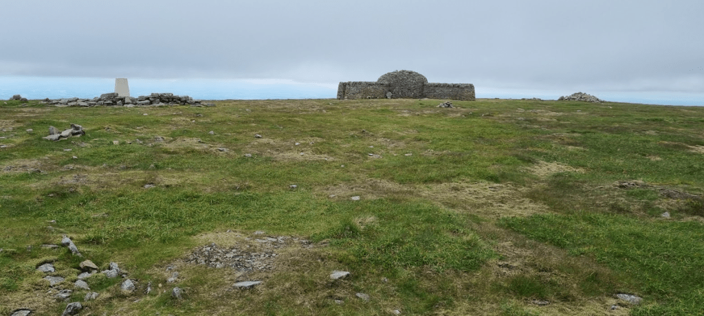
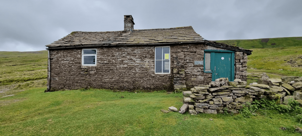
I didn’t hang about on Cross Fell as visibility wasn’t great. Getting there had been a combination of GPS and just heading cairn to cairn until I reached the wind shelter. The route down seemed vague at the start on my recce and was still vague this time. However I soon joined the path to Greg’s Hut.
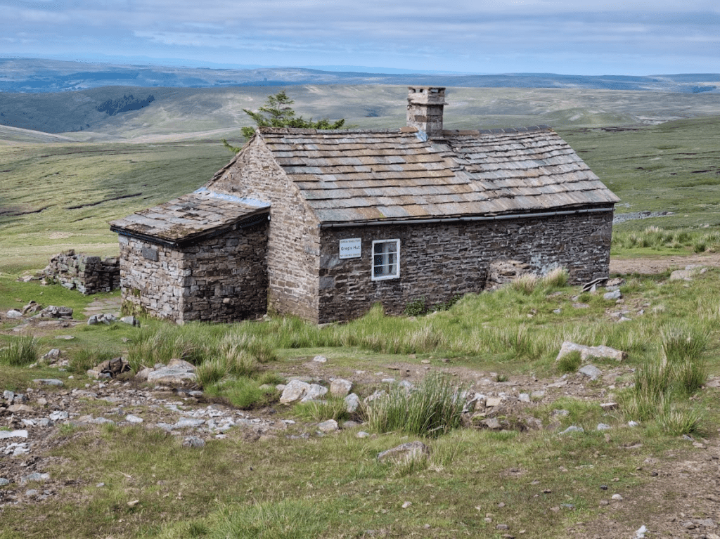
Greg’s Hut
I had a brief stop at Greg’s Hut – where I noticed that I’d had my shorts on inside out all day! If you looked very closely at the photo of me on Cauldron Snout you may already be aware of this… This race did appear to be characterised by an inability to dress myself properly.
On the path down from Greg’s Hut I was caught by Gerry Dance. It’s a bit of a trek from Greg’s Hut to Alston so it was nice to have someone to chat to – although Gerry now knows far more about phone boxes than he possibly ever wanted to! Soon we arrived in Garrigill and passed through the village before turning on to the South Tyne for the last few miles to Alston. Last year I kept running backwards and forwards along this part of the route, convinced I’d missed the checkpoint. Unfortunately this year wasn’t without incident either. About two and a half miles before CP4 I got a sharp pain in the tendon behind my right knee. It didn’t affect my mobility but it did hurt – it may well have been caused by my lean.
However all pain and fatigue was forgotten as I approached CP4 to be greeted by Rachel. Rachel was one my angels from last year and she was back volunteering at CP4 again after successfully completing the Spine Sprint earlier in the week. It was great to see her again, especially as this year I was in far better shape and was able to hold a proper conversation. There was a certain amount of deja vu as I sat in the same place and was fed lasagne (obviously, this is Alston after all) but it was great to be at CP4 in a positive frame of mind and with only slightly battered feet! I discussed my knee pain with the medic, her verdict was that nothing was ruptured or displaced but it was very inflamed. She would give me some pain relief before I set off from the checkpoint but there didn’t appear to be anything seriously wrong.
I was aware that I hadn’t washed since I started so I took the opportunity to have a shower before retiring for a couple of hours rest. Tomorrow I would be heading to the scene of my demise last year, how would I fare this year? Not really a cliff hanger as you already know I finish but it isn’t all plain sailing…
Despite my misgivings about a diet heavy on pulses and a small tent, I managed a couple of hours of sleep with no real problem. I returned to the main tent to see what I could get to eat. It turned out I was supposed to clear my tent when I left it – which on reflection seems sensible as someone else might need a sleep – but I didn’t. However on the Spine there is always a marshal to look after you and all my kit was brought out to me laid out pretty much as I’d left it in the tent. More importantly I was provided with breakfast and coffee. I don’t remember exactly but I’m fairly sure a bacon sandwich was at least part of breakfast.
I got on with dressing myself, packing up my kit and getting my bottles filled when I saw that Raj’s bag was in the tent. I checked the tracker and yes, he and Sabrina were still going! Sadly my friend Darren had pulled out at Malham Tarn, his calf muscle letting him down as he feared it would. I had plenty of time so I decided to wait a few minutes to see Raj and Sabrina. They both seemed in good spirits although Sabrina (not surprisingly) looked a little tired.
I mentioned kit check at CP1 but didn’t explain what happens so now seems like a good time to rectify that. At the start I was checked on a sample of my kit based on my race number. In order to stop people abandoning kit on the way (yes, some people do believe it or not), five items were checked at every checkpoint (ten at CP5). The check is made after you hand in your drop bag so you can’t present an item for kit check and then dump it back in the drop bag (yes, that’s been tried too). When went for my kit check the checkpoint manager was getting a little irate with two runners who were pretty much out of time at the checkpoint but had left their kit and were nowhere in sight. I wasn’t trying to be goody-two-shoes by arriving a kit check with 20 minutes to go but it did have its reward. After I was checked I was asked if I wanted anything else. ‘Like what?’ I asked, ‘Bacon sandwich for the road?’, ‘Yes, please!’ The photographer found this quite amusing and having taken a sequence of photos of me being kit checked and getting ready, she rounded it off with pictures of me walking out of the checkpoint with a bacon sandwich stuffed in my gob! I’m not sure if I want to see that photo or not!
There are no easy legs on the Spine Race and CP2 to CP3 is no exception. It is the shortest leg but it has plenty of challenges. The first starts immediately you leave the checkpoint, a climb of over four and a half miles distance to the top of Great Shunner Fell.
It’s a long path up to Great Shunner Fell
The wind shelter at the top of Great Shunner Fell
After conquering Great Shunner Fell it’s a fairly easy run down to Thwaite. The only event of note was passing a lovely lady who gave me a mint. Apparently she was offering them to every runner she saw so it was within the spirit of the Spine Race to accept.
The tea shop in Thwaite was open and as it was 11am it seemed like the ideal moment to stop for a mid-morning snack. A latte and a huge slice of lemon drizzle cake fitted the bill perfectly.
Not a bad snack!
The climb out of Thwaite is short and sharp and leads to a tricky path that has random rocks long it, crosses a rockfall and is just generally a bit annoying all the way to Keld. However after Keld it improves a bit as it crosses Stonesdale Moor and I got my first sight of the legendary Tan Hill Inn!
The Tan Hill Inn in the distance
The Tan Hill Inn – it isn’t on a slope…
You may have noticed that the Tan Hill Inn appears to be leaning a bit in the last picture. This might be a good time to mention my lean to the left (no I’m not going into politics). It had been commented a couple of times that I was leaning to the left. somehow I was unaware of this. One of the medics had seen me several times and said she wasn’t worried as it wasn’t getting any worse, I was just a bit weird. As I had no idea I was leaning I hadn’t noticed yet I was holding my phone at an angle…
Anyway the Tan Hill Inn was able to provide me with some perfectly upright nachos and a pint of Coke. I refilled my bottles – it was a hot day so I was carrying quite a bit of water – and headed into the notorious Sleightholme Moor…
…Except it wasn’t – notorious I mean. It was lovely. The Pennine Way was completely failing to live up to my expectation as a 268 mile long bog. The moor was slightly downhill, dry and spongy. It was absolutely fabulous to run on, especially as I was refreshed after my pitstop. I slowed down a bit after the initial exuberance had worn off but I still kept a fairly good pace to God’s Bridge. Last year I crossed this in the dark and was unaware of it. I have seen it in daylight since but I still stopped for a photo.
God’s Bridge
Crossing Cotherstone Moor was uneventful. I had recced it since last year so I knew what to expect. It goes on a bit but isn’t particularly tricky, especially as, as I previously mentioned, the Pennine Way wasn’t a big bog this year.
I think it was Grassholme Farm that provided today’s tuck shop. I bought a can of Barr’s Cherryade to help me through the last challenges of the day. It felt a bit like a roller coaster in reverse. The path climbed a cross a field, dropped a little climbed more, dropped, climbed, dropped, climbed… overall it climbed and it probably wasn’t as up and down as I remember but it it was a bit of a challenge towards the end of the leg. Eventually it became an easy downhill run towards Middleton-in-Teesdale. This year I was prepared for the two and a half mile run along the Tees to the checkpoint. It was starting to get dark but I reckoned I could make it without getting my headtorch out. The answer was that yes I could but I probably shouldn’t have done. Anyway I made it some time after 10pm.
As always I was offered food. I hesitate to comment on the relative quality of the food on offer at each checkpoint due to the legendary, near-mythical status of the Alston Lasagne, however the chicken curry, rice and naan bread I was given was a good, in my opinion, as anything I’ve eaten in a restaurant. While I was eating Lindley Chambers came in and sat with me and we chatted about kit for a while. Some comments on the kit list: it is not (as I have joked in the past) designed to see how much stuff you can carry and still run, it isn’t designed to catch you out with obscure and arcane requirements and it is most definitely not unnecessary. It is designed to ensure that whatever happens and however bad the weather may be, you will be able to survive at least until help arrives. If any of you ever do this race, don’t argue, don’t try and get round it, just take it, its for your own good.
After eating it was time for some rest. CP3 had a combination of tents like CP2 and a bunkhouse. The tents were very popular but I like a bed so I got space in the bunkhouse without a problem.
So, three legs down, still reasonably on schedule, I’ve developed a bit of a lean but my feet are reasonably OK, jut a couple of small heel blisters, all in all things were going as well as I could hope – so far…
So we left me at CP1 having arrived just ahead of schedule in good shape and I’d been fed. All I wanted next was to sleep – or at least rest. CP1 is at a scout centre and so has proper bunk beds – albeit a bit small and with plastic mattresses. I went for a lie down but didn’t do terribly well at sleeping. Firstly I felt that I couldn’t really have a noisy alarm as others were coming and going and trying to sleep – however I’d never tried to see whether the ‘vibrate’ alarm would actually wake me up. Also it was bunk beds. I managed to get a bottom bunk. Unfortunately the person that took the top bunk was having trouble getting comfortable and every time they turned over the whole bunk shook. I got a couple of hours lying down but eventually decided to cut my losses and get up before I originally planned.
I went back to the kitchen to see what was for breakfast. There was no bacon but I was offered beans on toast – with cheese on top. This put me in an incredibly good mood and so I ate my breakfast, filled my bottles, had my mandatory kit check and left CP1 just before 2am.
The day started without incident and I was rewarded for my early start by reaching Top Withins in time for sun rise.
This ruin almost certainly didn’t inspire Emily Bronte to write Wuthering Heights
Not a bad sun rise
One of the many things I had changed since last time was my use of my handheld GPS. Last year I simply downloaded the track files as supplied and loaded them onto my device. This year I had them on my watch, which made it easier to keep on track whilst using poles, and I had added waypoints to indicate various potential food and water stops which had been mentioned on the Official Spine Group Facebook page. As a result I knew I would soon reach another unofficial legendary feed station, the one run by the Craven Energy Triathlon Club. I was particularly looking forward to this as I had great memories of a bacon sandwich and rice pudding last year. It also came after a section of the Pennine Way that I found a bit boring and so was something to look forward to.
The Tri Club had put up various motivational signs on the lead in to their feed station
The early morning sun was creating some nice views
Like an oasis in the desert, the Craven Energy Triathlon Club feed station came into view.
A welcome sight and perfectly timed for breakfast
It was 6:30 in the morning, which seemed to be the perfect time to have breakfast. It will come as no surprise to know that a bacon sandwich was my breakfast of choice. Rice pudding and jam may be a less obvious choice of dessert but it slips down very easily. Add to that a cup of coffee and I was well set to face the rest of the day. These guys do this every year, summer and winter, for every single Spine runner and charge no money, they simply ask for donations to the local mountain rescue. There are many things that make the spine Race extremely special and unique and this is one of them.
Refuelled and very happy, I continued. I passed through Cowling and Lothersdale and found myself at Pinhaw Beacon. Up until now I had resisted the temptation to take selfies at trig points but for reasons unknown I decided this was the point to take the first.
Pinhaw Beacon – I don’t know why I took the picture
A much better view without me blocking it
This particular leg was quite a good one for additional food stops. Shortly after leaving Thornton-in-Craven I was greeted by the sight of the Cam Lane Tuckshop. I don’t remember eating anything but I did sit down and drink half a litre of some sort of cool fruit flavoured liquid, probably Oasis, which went down very well as the morning was starting to warm up.
So much love for the Spine Race on the route
Just after the tuck shop came the diverted diversion that wasn’t a diversion but was. Over the course of the race there were several diversions off the Pennine Way, usually to protect the more fragile parts of the Way from the impact of over a hundred people in a short space of time. This particular diversion took us around a field rather than across it. However we had been told at the last checkpoint that the diversion was no longer necessary and we were to follow the Pennine Way signs. however as the route as supplied had this diversion marked, diversion signs had to be deployed to indicate that we were to take the original non-diverted path. Clear?
The next major point of interest on this leg was the double bridge over the Leeds and Liverpool Canal outside East Marton. After this I would reach one of the most legendary and talked about points on the Spine Race.
Double arch bridge – obviously
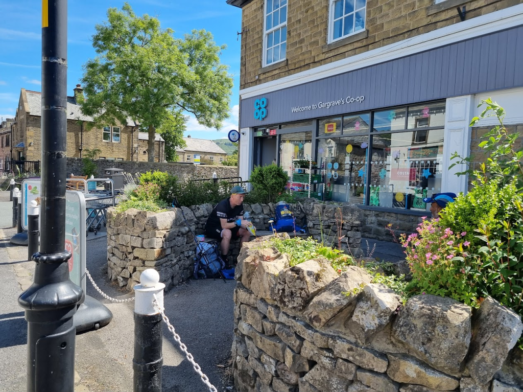
The Co-op at Gargrave has almost legendary status on the Spine Race. They are even warned to stock up on pies and sandwiches in anticipation of many hungry runners descending. Last year I went straight through Gargrave without stopping and so almost deserved to DNF. I didn’t make the same mistake this year. I sat in a small shelter and took my shoes off to give my feet an airing while I ate.
The Co-op at Gargrave!
A small snack to keep me going
The next section was quite pleasant and easy through fields until I got my first glimpse of Malham Cove. Monitoring station CP1.5 was just past Malham Cove. I had a freeze dried meal with me that I planned on eating there because I hadn’t had much to eat since leaving Hebden Hey had I?
I resisted photographing a single phone box until Malham
Malham Cove – I needed to be at the top of that
After climbing the steps up Malham Cove to the limestone pavement (of Harry Potter fame) I saw Sabrina. I was a little concerned by this as I was expecting her to be several hours ahead of me. I caught he up on the pavement , where she told me she was struggling to find her way. To be fair finding a ‘good’ route across the limestone is hard at the best of times but she told me she had been quite ill and was struggling to keep any fluids down. Last year, when I was in trouble (much more trouble) Les Binns had helped me and so it was an absolute no-brainer to stay with her until the monitoring point at Malham Tarn a couple of miles further on. In fact regardless of my experience from last year it was the only thing to do. It wasn’t far, there would be other runners but part of the Spine Race ethos is to help each other. Anyway it wasn’t so great for her as she had to listen to me babbling on for the next hour or so. I did still manage to pose for photos when the photographer appeared.
We got to CP1.5, which was being run by the legendary John Bamber. I explained the situation and the medic immediately started rehydrating Sabrina and after a while she looked much better. I told her that I was happy to continue with her to CP2 if she wanted. This would have been better than leaving her on her own but a much better option appeared in the shape of Raj Mahapatra. Raj had three Spine finishes to his name as opposed to my one DNF and said he would happily team up with Sabrina. I could have gone with them but I felt that I would add nothing to the party. It was tempting to run with a three time finisher but I felt I needed to do this on my own (not that you are ever on your own in the Spine but hopefully you know what I mean). As it happened I was now pretty much back on my original schedule, having been slightly head when I left CP1. I wished them both well and set out for Fountains Fell, Pen-y-Ghent and, for me, the worst part of the whole race (probably, Blenkinsopp Bog runs it close), the Cam High Road.
Fountains Fell was quite pleasant in the sunshine, certainly a world away from my experience last year in the dark. I was a little nervous about the scrambling on Pen-y-Ghent, last year I was with others, this year I would be doing it alone. As it turned out it was OK, a couple of moments of indecision but I was soon on the path to the top. I’d done a couple of videos on Facebook Live earlier in the race, mainly because it was easier than typing a Facebook update. I decided it would be quite cool to ‘broadcast’ from the top of Pen-y-Ghent however I don’t remember saying much interesting.
Pen-y-Ghent – you sort of climb up the steep bit on the left but the top is much nearer the middle
Obligatory selfie at the top
As usual the view is much better without me in it
After Pen-y-Ghent it was down to Horton in Ribblesdale. I had been told at CP1.5 that he tap on the toilets there was the last chance I would have to fill my bottles. I know how long and dull the section from Horton in Ribblesdale is so I took the advice and filled my bottles so at least that way I would only be bored, not bored and thirsty.
The last nice view before dark and the Cam High Road
There isn’t much to say about the rest of this leg fortunately. The Cam High Road is terrible apart from one short section where, bizarrely it coincides with a road and is asphalted. I turned off the track to Gaudy Lane, which think I navigated with a combination of luck and GPS. I found a hedgehog and some marshals in Hawes and, having asked the latter not to run over the former, I started on the last mile and a half to CP2 at Hardraw. This was completely uneventful apart from a small amount of amazement at the amount of sheep poo there appeared to be on the last section of the path in Hardraw, although after the Cam High Road almost anything would be interesting. Anyway I arrived at CP2 at ten past two in the morning, which was pretty much exactly on my schedule. I think I was fed a chickpea casserole. This was very nice but I was slightly concerned about the amount of beans and pulses I’d eaten since the start of the race, given the accommodation at CP2 was one man tents.
So the first two legs of the Spine are complete, I’m on schedule and feeling OK, would it last? If anyone is interested all will be revealed in the following instalments…
I started this blog to record the mistakes I made last year to help me plan a successful campaign for the Summer Spine Race 2022. I’d like to think it has been a little more than that over the past year as it has documented my preparation, other races and thoughts as I approached the start line on the 19th of June 2022.
I guess this blog post should start with a spoiler alert – I finished. I think many of you reading this already know that and for anyone interested it is a matter of public record on the Open Tracking website so I’m not really giving much away, other than to say that whereas last year I couldn’t wait to write this blog and to start the process of understanding my failure, this time I’ve spent the last week eating, drinking, staying in a pub, visiting a vineyard, eating, drinking, visiting some telephone boxes, eating, drinking and finally going to a festival of fake bands where I also ate and drank.
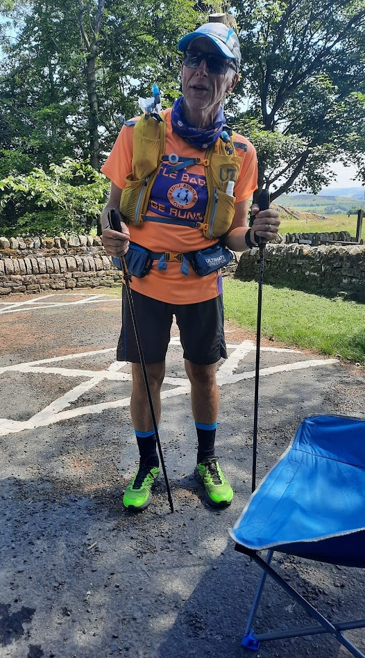
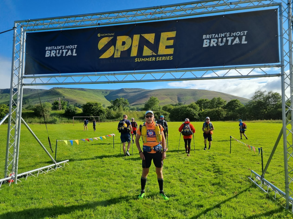
Anyway now I’m finally getting round to the blog so lets start. I booked overnight accommodation a couple of miles from the start at Rushop Hall, a very nice B&B which provided me with breakfast two hours earlier than normal in order to ensure I started the Spine Race well fed. We travelled up on the Saturday before the race to arrive at Edale for my 2-4pm timeslot for registration and kit check. Kit check went reasonably smoothly – there was a question regarding the length of the baseplate on my compass but it was pronounced good by the kit guru Lindley Chambers. I wasn’t trying to ‘get away’ with anything, it was a decent compass made by Silva but it was also the cheapest in their range and hence had a shorter baseplate with no magnifying lens, unlike the ‘standard’ compass favoured by most runners. It was also checked for its ability to point North. I thought this was unnecessary until I was told a number of people had kept their compass against mobile phones and demagnetised them or even reversed the direction completely! I was photographed and made a feeble joke about whether or not my feet should be photographed as they were the bit that would be sticking out of a bog. Despite my obvious lack of ability at humour I was still given a race number (357) and that was it – I was now registered for the Summer spine Race 2022!
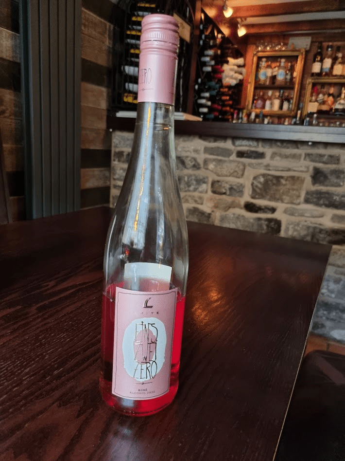
We went to the B&B where I sorted out my kit ready for the next day and Sharon secured us a table in a very nice Italian restaurant in Castleton. It is a testament to how seriously I was taking this year’s race that I, for the first and hopefully last time in my life, ordered a bottle of alcohol free wine.
It wasn’t totally horrible and the food was excellent
The following morning, after more sleep than I expected to get but not as much as I would have liked, I got up and dressed as a runner – almost, it took two attempts to get the shorts on the right way round. We went for breakfast, came back to the room, where I took my top off and put that back on the right way round too. Bottles were filled, last minute checks were done and we drove to the start at Edale, where I dropped off my drop bag and had my tracker fitted. This was essential not just for my safety during the race but for the army of ‘dot watchers’ that enjoy following the progress of runners during the event. I knew many, many of my friends and running acquaintances would be following my dot but occasionally random people will become invested in a particular dot because of a picture or story on the Spine Facebook page, or that dot has run with a friends dot for a while, or any other reason that causes them to be interested in a particular runners progress.
I also met up with my 2016 MDS tent mate and fellow Spine Runner, Darren Wilson. I wasn’t expecting to see much of Darren during the race as he is much fitter and younger than me. However he had been suffering form recurring calf problems and was wearing brand new running shoes in an effort to alleviate the issue (for those that know about/are interested in these things, he had been running in zero drop shoes without realising and had switched to some with a 6mm drop)
Anyway the moment I had been waiting for almost since my 2021 DNF was finally here, the start.
At the start – hopefully a bit less clueless than last year
Last year I started at the front of the pack and tried to run with the fast guys and, as we know, it didn’t end well. This year I had a plan which involved averaging about three miles per hour and arriving at CP1 at around 10pm.
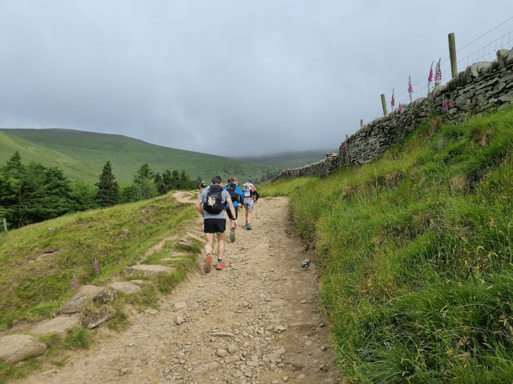
At one second past 8 am (according to my tracker) we were off! I started somewhere towards the middle of the pack and ran chatting with Darren until he gradually edged ahead of me. Looking ahead and up I could see I was unlikely to be distracted by the view from the Kinder plateau – things looked a bit cloudy to say the least.
Heading up into the clouds
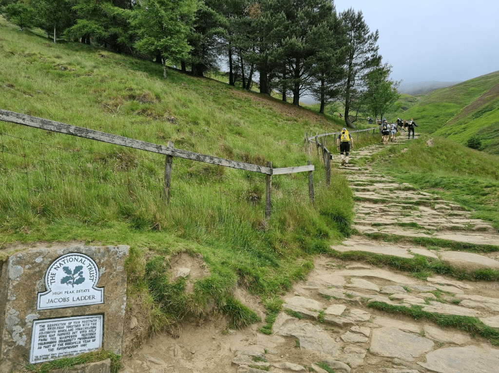
Soon I found myself at the foot of Jacob’s Ladder, the second biggest climb on the Pennine Way according to Damien Hall and if anyone should know it should be him. I got my poles out and started the long climb.
Jacob’s Ladder – lot’s of people ahead of me this year as it should be. And a lot of cloud…
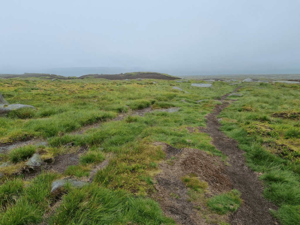
As I expected it was very misty on the plateau. I had the route on my watch, and the runners were still sufficiently closely spaced, so route finding wasn’t a problem but I was still very aware that I had to keep an eye on my navigation to avoid being caught out.
For much of the crossing of the plateau I was trying to keep the runner ahead of me in view. After a while I caught up with said runner, who turned out to be Sabrina Pace-Humpreys, a first time Spine runner who asked if I had any tips. As all I had was DNF to my name, I didn’t feel I was the best source of advice but I told her to to look after herself as that was my biggest mistake in 2021. I also warned her that some of the moors would go on for ever and that Stoodley Pike never got any nearer, no matter how long it seemed you were running towards it.
Bleaklow Head – certainly a bit bleak anyway
After a small amount of indecision on a short climb at Torside (there were several paths that all lead the same way, the runner in front of me didn’t take the one on my GPS so I was about to go back until a marshal called to me to tell me I was going the right way) I was up onto Torside and used my experience from my recce to take the correct path through the heather. Several people didn’t and to be honest it doesn’t really matter but it was nice to know that, for once, I was on the ‘official’ path. Then it was the steep decent off Torside, across Torside Reservoir and up towards Laddow Rocks. This was a significant point to me as it was the end of the final recce of the first leg I had done with Sharon earlier in the year.
As I ascended, the clouds started to clear a little and I wasa rewarded with a decent view.
Looking back from Laddow Rocks
Wessenden Head Moor seems endless but isn’t and in fact today ended much better than usual. The final climb from the moor is up to the A635 where I could see Snoopy’s Food Van! This van isn’t mentioned much in conversation about the refuelling on the Spine Race as it is often gone by the time the majority of the racers get there. However this year it had hung on as the ladies running it could see thirsty runners coming across the moor. They only had diet drinks left when I got there but a coffee and a can of something claiming to be fruit flavoured was very welcome.
No idea which one is Snoopy (if either of them) but they were a welcome sight!
Not only had I had some unexpected refreshment, the weather was improving! It hadn’t been really bad up until now, just a bit grey, but some blue skies were definitely a welcome sight to me at least.
Black Moss Reservoir with some promising blue sky
Of course, welcome though Snoopy’s was, the legendary food van, there for every single Spine Racer, is Nicky’s. This year was particularly exciting as Nicky’s was now in a large container so had indoor seating and a toilet. However even these features seemed unlikely to justify the huge number of cars in the car park… and music.. and purple smoke. It appeared that an Asian Wedding – or at least some part of an Asian Wedding -was being held in the car park. It was certainly a lively affair, especially when the fire crackers were set off!
Seems a strange location for a wedding but I guess there was a reason for it
Inside Nicky’s – not an easy place to leave
Bacon… the first of many I’m pleased to say
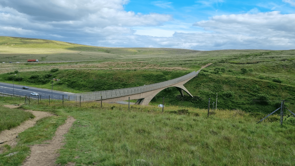
After Nicky’s it’s a trip across the M62 on what I think is the biggest footbridge in the UK and along Blackstone Edge until Blackstone Edge Reservoir and its compatriots leading ever onwards to Stoodley Pike.
The M62 Bridge and some more blue sky
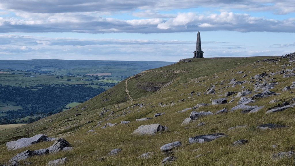
Finally Stoodley Pike came into view but I wasn’t fooled. Although the Pennine Way goes right past Stoodley Pike, it isn’t a straight line form the first view of it to the monument and so it takes a while before you actually reach it.
Stoodley Pike, it seems so near
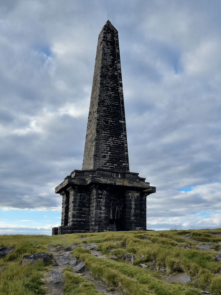
After A while I actually felt I was approaching the structure and at least this year I could see it, last year I arrived at this point in pitch darkness.
Stoodley Pike – made it!
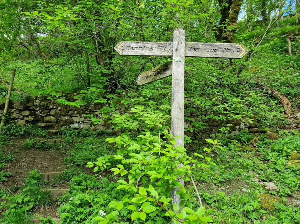
There are still over 5 miles to go from Stoodley Pike to CP1 but for me it still makes me feel I’m almost there. Last year the checkpoint was actually in Hebden Bridge but this year we were back to the scout hut at Hebden Hey. This made this leg slightly longer but it did mean a particularly horrible section was got over with on the first leg rather than the start of the second. A short section of the way is between two dry stone walls in a narrow, weed and rock filled almost trench. I was quite happy to get that bit done and hopefully have a better start to leg two than last year.
A clearly signposted diversion took me off the Pennine Way and along a road until a turn off onto a path towards the checkpoint. I met a few runners coming out of the checkpoint that had decided not to stay for too long, including Darren. He’d had some food and a shower and was pressing on through the night. My plan was to get some rest and leave in the morning. After negotiating the slightly tricky ‘steps’ to the scout hut I was greeted by the ever enthusiastic volunteers and reunited with my drop bag and a large plate of lentil stew. My plan had me arriving at 10pm. I was about 40 minutes ahead of that so all in all the first leg seemed to have gone very well.
When I started this post I thought I would cover the first two legs but I seem to have gone on quite enough for one post, and anyway the next leg is the longest and a small amount of interesting things happened (well, one anyway) so we will leave me happy at CP1 and save the second leg for another ‘thrilling instalment’ as they say!
Ideally by now I would have recce’d every section of the Pennine Way. However that’s 268 miles, a lot of travelling and a lot of time. I have recce’d all of the first leg, I’ve revisited Blenkinsop Bog – sorry, Common – always get that wrong, as well as as God’s Bridge and some other assorted bits of bog. And let’s not forget I spent many hours in bogs just so I could do a small section of the Pennine Way in the Cheviots.
However there was one section of the Pennine Way I really needed to revisit before the Big Day (it deserves capitals) and that was Cross Fell and the path to Alston. Those that have read my earlier blog entries – in particular ‘So what went wrong – Part Three?’ – will know that I had a very bad time and a great deal of confusion and delirium when I traversed this part of the course last June. I was relatively coherent at Dufton but as the light faded so did my mental competence until I was running backwards and forwards, first along the track from Greg’s Hut to Garrigill and then, even though it was now light, along the river between Garrigill and Alston.
Since the race, I’d extensively studied the OS map of the area (something I should have done more of before the race) and was fairly happy that actually the path from Greg’s Hut to Alston was quite easy to follow. However in order to banish any demons I wanted to run it again to be sure. Also I’d been guided across much of the Fells and so wanted to (OK, needed to, ‘wanted’ is perhaps overstating things) traverse Cross Fell again, navigating myself.
Anyway what his is all getting to is that a weekend was selected, (very nice) accommodation was booked and a plan formulated which was to see me standing outside the Stag Inn in Dufton at about quarter to ten on Saturday morning. The Stag Inn was the location of the Spine Safety Team, also had I gone in there and got some food and drink after I spoke to them the following few hours may have been different – although I was in a sufficiently dodgy state by then it might not have made much difference.
The Stag Inn – does a good burger and a pint I’m told
Sharon had dropped me off in Dufton and had gone back to Knock, a very small village a couple of miles away to park the car. She would run from Knock and meet me a mile and a half into my run on the Pennine Way in theory. In practice she arrived at the Pennine Way before me, didn’t realise it was the Pennine Way, and continued running ahead of me until after about half a mile she came to a gate and saw me puffing along desperately trying to catch up with her. As this was my last recce and the race is only a month away, I was carrying full kit, including two and a half litres of water, so my pack weighed around 7kg.
Most of the Pennine Way markers point to a fairly obvious path…However some simply give a rough direction and reassurance that you are at least in the right place
The farm track gave way to a small path which varied in existence as we climbed up towards Knock Fell. A combination of GPS and the fact that ‘up’ was the main attribute of this part of the route meant that we got to the top of the ridge with little drama. I was also carrying my filter bottle. As I’d never used it and as our route was alongside Knock Hush (according to the OS map anyway), a small stream, I stopped and filled the bottle and tried drinking from it. The water tasted OK. Sharon tried it as well, on the grounds that we might as well get ill together. On reflection, given that our accommodation only had one toilet, that was probably a bad idea. However we both survived with no ill effects.
We reached Knock Fell without any major incident but it was getting windier and the sky was getting cloudier. Soon I decided it was time for a jacket and gloves. I’ve bought a new OMM Halo jacket as years of neglect and mistreatment had caused my old one to start to delaminate. I also have an OMM Kamelika jacket, which is a bit more substantial. I’m planning on taking both on the event and using the Halo if the conditions aren’t too bad but switching to the Kamelika if the weather looks like it is going to take a turn for the worse. I would have preferred the Kamelika on this recce, the Halo did the job but it has a much simpler hood with no adjustment possible. It fits me fairly well but as the wind picked up the hood flapped and rattled in a quite deafening way. Why hadn’t I taken the Kamelika given Cross Fell’s reputation? Because I’m a nice person and I’d lent it to Sharon. Anyway whilst, as I said, the Halo had its shortcomings it did keep the wind and the (fortunately) small amount of rain we experienced out. Obviously I have no idea what the weather will be in a months time but my current expectation is that I will use the Halo from the start to CP3 and probably use the Kamelika from there on – certainly over Cross Fell and over the Cheviots anyway.
The clouds are gathering..
On my only previous trip over Cross Fell it had mostly been dark and so I wasn’t aware you can see the ‘Giant Golf Ball’ antenna on Great Dun Fell on the way up. I had pointed it out to Sharon, and also made her aware that we wouldn’t be simply heading straight towards it, even though we would pass it later.
Later arrived, and we were soon walking along the path below the antenna installation. The fact the path was below the installation, coupled with the size of it, meant that it provided welcome respite from the wind, a fact a fellow hiker (we weren’t really running much at this point) was making good use of as he had sat down for a rest.
Fore!
I haven’t said much about the path so far, this is mainly because anyone that follows this blog could probably guess, it’s a mixture of bog and slabs in the main, with a few grassy sections that – in May at least – aren’t quite a bog.
The wind was getting worse but we were committed by now and continued on to Little Dun Fell. This was a key point for me as it was where I found some shelter and some loose rock on the Spine Race. I didn’t want to leave the shelter and I didn’t want to cross the loose rock, so I ran around in circles until someone else appeared and followed them to Cross Fell and Greg’s Hut. In daylight, and with a brain functioning as well as it ever manages, the reality is that it is a small and easily crossable patch of loose rock, and not the terrifying opportunity to twist an ankle I believed it to be before.
Cross Fell from the ‘scree’ at Little Dun Fell
As we approached Cross Fell, the wind seemed to increase and the cloud got lower. I’ve been in these positions before and always felt that it is wrong that fog and strong winds should be able to exist together – surely the wind should blow the fog away? Of course the reality was that this was low bank of cloud being driven onto the fells by the wind and so one was actually a consequence of the other. Anyway when I’m up here next month the weather will be what it will be and no amount of me complaining that ‘it’s not fair’ will change it. Actually I was quite glad the weather wasn’t perfect for the recce as, whilst it could be a lot worse next month, it at least allowed me to experience slightly adverse conditions.
After a short climb upwards (through some bog, naturally) a couple of windswept adventurers took a very bad selfie at the trig point.
No idea why the arm of my sunglasses is outside my hood!And without anyone blocking the view – note the approaching cloud…
As we left the fell, the visibility had reduced to the point we were going cairn to cairn. Whilst I’m reasonably happy I could have found my way down without it, GPS makes life a lot easier. Even then we had to retrace our steps as, although we weren’t far away from the path, we were getting further and further into the inevitable bog. To be fair quite a bit of the ‘path’ was a bog. For reasons unknown I decided to demonstrate the limits of grip of graphene enhanced trail shoe soles and fell flat on my back when I attempted to stop on a piece of rock covered in slimy wet peat (bog).
After a short while we joined the path to Greg’s Hut to the right and the ‘Pennine Journey’ to the left. The plan was for Sharon to take the Pennine Journey path and return to Knock where she had left the car, while I would continue on the Pennine Way back to our accommodation at Alston. I was aware the weather wasn’t as good as it could be and quizzed her as to whether or not she was entirely happy for us to split up. I was happy as I knew that, despite evidence to the contrary from the last time I did it, my path was very clear and easy to follow. We had no idea what Sharon’s would be like.
She assured me she was happy to continue as planned. She did however have very cold hands as she doesn’t usually wear gloves, relying instead on putting her hands in her sleeves. Unfortunately that didn’t really work with walking poles. Fortunately the Spine kit list specifies that two pairs of gloves must be carried so I gave her my spare ones. With that sorted we went our separate ways, would we ever see each other again? I will mention at this point that we were both using Garmin Livetrack so that we could at least check on each others progress.
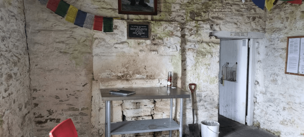
The only even slightly interesting thing on my route was Greg’s Hut, half a mile down. After that it was six miles of track to Garrigill. Six miles I’d run all of before, quite a lot of it several times and very little of which I remembered. Anyway this time I did something sensible and stopped at Greg’s Hut and had a snack before continuing.
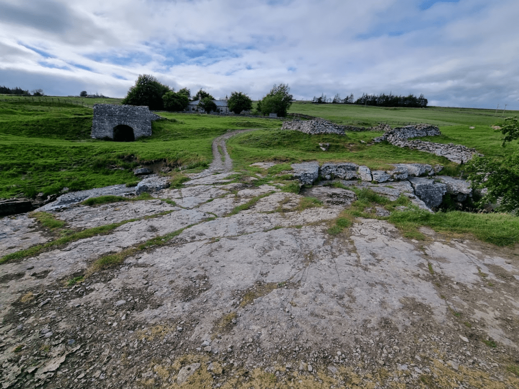
Greg’s HutInside the hut – the door leads to the ‘bedroom’‘Greg’
Last time I was at Greg’s Hut I didn’t go in – probably a mistake, no, definitely a mistake. I did however take a picture of it and it’s that picture that is on the cover of my fundraising page. Last year I raised money for Mesothelioma UK as my Father-in-Law, Archie, hade recently been diagnosed with the disease. Sadly he passed away in November but received some amazing end of life care from Marie Curie and his local hospice, Accord. As a result this year I’m raising money for both of those great organisations. If you like my blog and would like to support me then obviously a donation would be wonderful but just sharing my page and letting people know what I’m doing would be great too. https://donate.giveasyoulive.com/fundraising/colins-summer-spine-race Thank you!
OK, charity appeal over, on with the bog, sorry, blog…
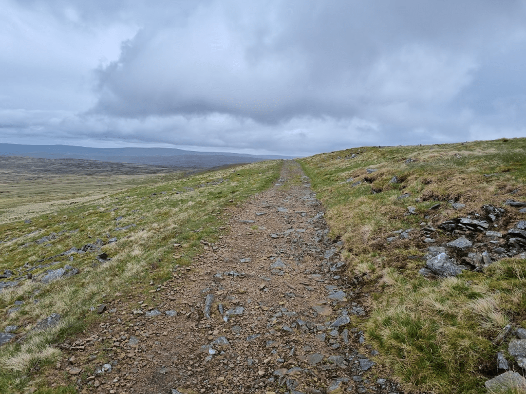
The track from Greg’s HutLooking back across to the fells – the ‘golf ball’ on Great Dun Fell can be clearly seen
After Greg’s Hut the track continues in a fairly rocky lumpy sort of way until it quite abruptly becomes a smoother, sandy coloured, dirt road. I remember this very well and very badly from the Spine Race. I remember the track, I remember numerous imaginary conversations with various imaginary people telling me the checkpoint was on the track somewhere, but they kept moving it so I kept running backwards and forwards looking for it.
If you look carefully you can see the sandy path snaking off into the distance
After several miles of running in the same direction Garrigill appeared.
Downhill to Garrigill
On the Spine race I was met by a Safety Team member as I joined the ‘main road’ through the village. Somehow at this point I was coherent enough to convince him I was OK to continue. This time I met a 90 year old man who had lived in Garrigill all his life and had built the rather nice bungalow at the end of the track by the road. We had a brief chat about High Cup Nick and Cross Fell and I continued along the road until I turned off onto the path to Alston.
The South Tyne – just need to follow this to Alston….I’m not sure how many times I crossed this bridge on the Spine Race – only once was necessary
It shouldn’t have been difficult to follow the path…
…just follow the river……and the signs……a lot of signs!
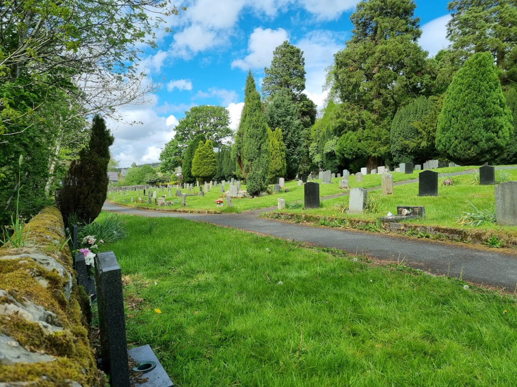
Soon I arrived at Alston. The first thing I saw was the cemetery next to the Youth Hostel. When I arrived at the checkpoint on the Spine Race I was more fit for the cemetery than to continue the race but thanks to Rachel and Max I somehow left the checkpoint and continued as those that have read ‘So what went wrong? – Part Four (the last bit)?’ will know.
As usual, I found a graveyard
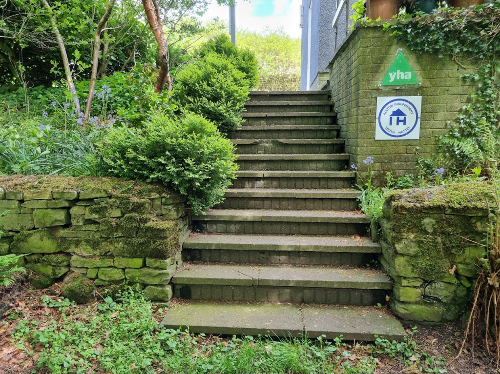
I paused at the Youth Hostel and promised myself I would be back at it with a smile on my face and fit to continue this year. Rachel has told me she will be there again but this year I hope she will be looking after someone that is going to Kirk Yetholm, not Carlisle A&E!
I wasn’t quite dead but this was definitely a Stairway to Heaven last time!Checkpoint Four – AKA Alston Youth Hostel
From the Youth Hostel it was a short jog through Alston to our accommodation. I checked up on Sharon on the Livetrack and was delighted to see she was nearly back to the car. I phoned her. she was also delighted to know she was nearly back at the car. Apparently the latter stages of her route crossed numerous fields and farms with non-existent stiles, tied up gates and killer cows (no really, she was told the cows had killed people a couple of years ago – but this year they seemed OK and hadn’t killed anyone yet). Fortunately with the help of a few locals, the GPS and some determination she made it back to the car and arrived back at Alston less than an hour after me.
So, my last recce, a test with full kit and on the part of the route that was effectively my Nemesis – I may have got further but it was Cross Fell that did it. How did it go? I think it went well, the kit was all good. I was wearing Dexshell waterproof socks and would thoroughly recommend them. They were very comfortable and protected my feet from the worst of the bog. It was still a cold, unpleasant experience stepping in a bog but at least it wasn’t cold, unpleasant and wet. The Halo jacket was OK but the Kamelika is definitely being packed in my drop bag at least. Do I feel ready? Not sure. I’ve been having issues with my right calf and hamstring and so I don’t feel as fit and certainly haven’t done anywhere near as many miles as I had at this point last year. On the other hand mentally I feel far more prepared, I know what I’m taking on, and I have more of a plan than I had last year. I have to be positive and believe I can finish or what’s the point of starting?
There may be one more blog entry about my final preparations and kit – or I may leave it so late that there’s no time to blog. Anyway there will undoubtedly be social media posts – I’m trying to build my Twitter following @colinh_runs if you want to follow me. Please also do visit my fundraising page https://donate.giveasyoulive.com/fundraising/colins-summer-spine-race Now, more than never before, for me at least, The Only Way is Pennine!
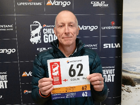
The Cheviot Goat Ultra was one of those events I’d never heard of or considered entering until one of my friends mentioned it – however as I may have mentioned before in this blog, I’m very easily lead. It also seemed like a very good idea… reasonably good idea… good idea… definitely an idea anyway, as the last leg of the Spine Race goes through the Cheviots and that was the bit I didn’t get to. It was also in December so my theory was if I could get round the Cheviots then it should be a breeze in June.
Anyway I entered, Storm Arwen happened, the route got modified, we travelled up to Alnwick for the start, Northumbria declared a state of emergency and the race had to be cancelled less than 24 hours before it was due to start.
After a couple of weeks the organisers presented us with three options: transfer to the December 2022 event, a new event in Summer or a rescheduled 2021 event in March. As I was primarily using this a Spine training run, the March event seemed perfect. We would also have literally twice as much daylight as we would have had in December, which, to me at least, was a definite win.
As it happened the two people that got me into the Goat in the first place also took the ‘March’ option so the banter regarding who was most likely to drown in a bog (me), who was most likely to get hopelessly lost (me again) and who was most likely to get hopelessly lost and then drown in a bog (still me) could continue.
Since December I had realised that had the event gone ahead I would have been at best a DNF and at worst a casualty. By all accounts the weather that weekend on the Cheviots became horrendous, freezing temperatures, high winds and snow. To be fair many of the people that do the Goat do it to test themselves in precisely those conditions. I realised I had definitely ‘dodged a bullet’, as one of the people I chatted to on the race that went up onto the Cheviots on the original date of the race put it. In order to be a little more prepared I had a bargain £30 down jacket from the Trespass closing down sale and spare gloves, hat and waterproof socks in my pack. As this was to be a Spine training run, I basically had virtually all my Spine kit in my pack (apart from my poo shovel, this is a recent addition to the kit list and I’m still researching which shovel is best for burying poo with – it’s a glamourous race, the Spine). In fact my pack was so large compared to many others that was asked if I was planning on bivvying out overnight on the Cheviots.
Race check-in was done on Friday evening, it was quick, efficient, I was given a map, a couple of trackers were attached to my pack and my photo was taken in case it was needed for an obituary. Mountain Rescue also checked I had spare clothes and a survival bag as their preference was not to need to find me at all but if they did have to then the preference was to find me alive and relatively warm in my survival bag, rather than a hypothermic medical emergency. Oh and they gave me a map, which was nice but I felt unlikely to help.
Not the last photo ever taken of me as it turned out
Anyway I had my pack packed, my two drop bags packed and my race clothing selected, I was as ready as I was ever going to be. The weather forecast looked good, I had a new GPS watch with maps and everything on it plus my handheld GPS so I was hoping not to get too lost. I reckoned I was as ready as I was ever going to be so at 4am on Saturday 19th of March 2022 I got out of bed, got dressed, ate porridge and Sharon drove me to the start at Ingram.
One thing the ‘Essex Goats’ were agreed on was the choice of footwear for the event, Inov8 X-talon Ultra 260s – even if Jackie had never actually run in hers…
Essex Goat feet!
From this point onwards I am going to have to upset Drew, one of the the race organisers. The Cheviot Goat has a reputation for being a tough race in difficult December weather. We were asked at the race briefing, in order to ‘protect the brand’, not to post pictures with blue skies and sunshine. I’m fairly sure that was joke but if it wasn’t then if any of the Cold Brew team should happen across this blog then please stop reading now…
Waiting to start – the Moon looked a lot more impressive in real life
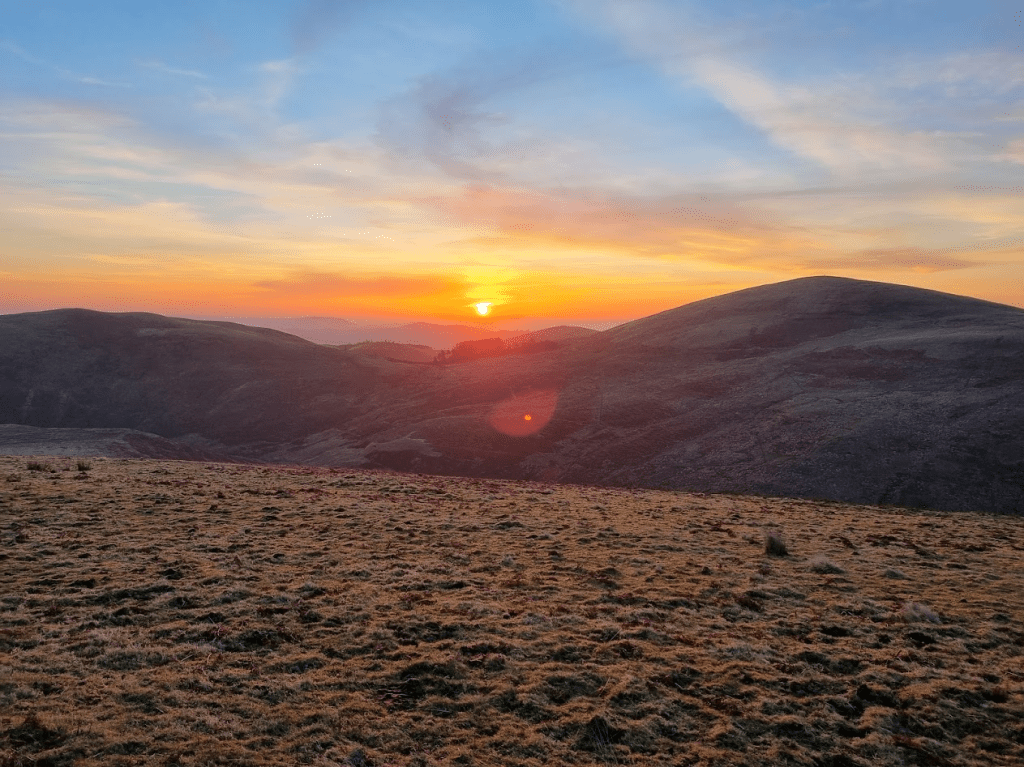
At 6am on the dot we were off and jogging along a reasonably decent track with a gentle incline. Soon after we got to see the most beautiful sunrise, which as usual, my photographic skills failed to do justice.
Great start to the day
As I passed the Thieves’ Road Plantation I was remined of why the event was postponed from December.
The devastation wrought by Storm Arwen was still clearly visible in places
After about eight miles of deceptively easy running, we turned off Salter’s Road and onto moorland. Obviously I face planted fairly soon after. It was a bit of a comedy fall as I stumbled forward, the weight of my pack stopped me quite regaining my feet but I managed to run, bent double, until I took the tactical decision to stop running and fall gently forward into the grass. no harm done but a warning that I needed to be a bit more careful from now on.
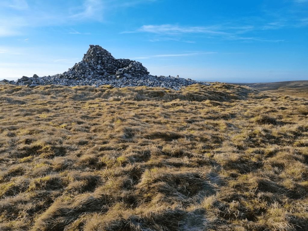
The course then took an upward turn for a fairly steep climb up to Hogdon Law and its very impressive cairn.
The cairn at Hogdon Law
From there it was downhill, becoming quite steep downhill, with great views until I reached the additional water point. I had decided to carry 2.5 litres of water (actually Tailwind) from the start and so had plenty of water and so left it for those that might need it.
More blue skies – sorry Cold Brew!
Obviously what went down had to go back up again but I don’t remember anything too horrific and after passing Shillhope Law I dropped into Barrowburn and the first checkpoint. I arrived at almost exactly 11am, a full hour earlier than I had expected. I was given soup, coffee and my drop bag. At this point things were going so well I didn’t feel the need to even open my drop bag. I refilled my soft flasks from the two hard bottles I was carrying and decided that should be enough liquid. I had purchased a filter bottle, partly to give me the 3 litres of water capacity required for the Spine but also as an emergency water source. I had seen enough streams already to be confident that I could find water should I need to. To be fair, I was regularly finding water with my feet whether I wanted to or not.
The next leg was the one I was most interested in as it included a few miles of the Pennine Way. However before then there was the small matter of an additional loop up to Windy Gyle, which had been added to make up for the reduction in mileage caused by the removal of the trip into Scotland after Storm Arwen. The extra loop was fairly easy to follow but it did include a very steep drop down to Trows burn, followed naturally by a steep climb back up.
Once at Windy Gyle I was very excited to find a sign for the Pennine Way. One of my fellow runners could see my excitement and very kindly took a picture of me with the sign.
Hoping to see this again in June!
As I was now on the border between Scotland and England I felt I should take photos to show how different each country is.
Scotland – I thinkEngland – or is it Scotland?…
Once on the actual Pennine Way I wasn’t sure if I was happy or disappointed. The path was slabbed like several of the boggier sections I had covered in June. On the one hand this was a good thing but I couldn’t help feeling slightly disappointed that after all that effort to get onto the Pennine Way in Cheviots it was much like much of the rest of it.
The Pennine Way – looking reassuringly familiar
The next 5 miles would take me to the top of the Cheviot. Although that would be the highest point of the run, I wasn’t too worried. Firstly, the path was easy, mostly slabbed with a few rougher sections. Secondly there was actually only about 200 metres of climb from where I was to the top. Obviously being me I couldn’t make this totally straightforward and sure enough I learned a valuable lesson. There were various points on the Pennine Way where the slabs were either missing, leaving a bottomless bog, or just slightly submerged and safe to walk on. Within sight of the summit there was such an area. I very carefully probed with my walking pole to find the slightly submerged slabs. The valuable lesson is to put my foot in the same place as the pole found the slab, not a few inches to the left into a bottomless bog… I should confess this wasn’t my first major bog related error. At some point, I’m not sure where, I was going uphill through bog, wondering why so much water could stay uphill instead of doing the decent thing and running to the bottom. I was with two other runners at this point. At one particularly wet section my companions turned sharp right to go around it. We were following a fence line and I noticed a rail along the bottom of the fence I could kind of slide along over the wet bit. what I hadn’t noticed was that the wet bit extended further than the rail. I pulled myself out of the bog and my fellow runners were kind enough not to laugh too much.
I finally arrived at the top of the Cheviot which, if I’m honest, was a bit underwhelming. It’s not a very pointy peak but it does have a big pointy concrete thing to show you where the top is.
At the top of the Cheviot – happier than I look
I was very happy as I’d reached the Cheviot by quarter to three in the afternoon and so felt fairly confident of achieving my next aim, to get to Checkpoint Two before dark. After coming off the out and back section from the Cheviot I was a little unsure of the exact route, it was down and along a fence line but there was a stone wall there as well and a lot of loose rock. I picked my way carefully downwards until the route became more obvious. I should have been grateful for the excitement as the next few miles weren’t my favourite. It was a couple of miles jogging along with a fence on my right, until I crossed Salter’s Road where a marshal told me to switch to having the fence on my left – I could barely contain my excitement.
After the small summits of Bloodybush Edge and Cushat Law it was back down to Salter’s Road and an easy jog to Checkpoint Two. I was there by quarter to six and assured by one of the marshals that my ambition for a same day finish was very realistic. I was less certain as I knew it would be dark in an hour or so but it was still good that someone had confidence in me. I had more coffee and got my bottles refilled with water. I picked up two sachets of Tailwind in case I wanted to add them to my bottle but I never did. Realistically I knew I probably wasn’t taking in enough calories but I felt OK so I trusted my body and set off on the last leg of the adventure.
After half an hour the sun set and it started getting dark.
Sunset
It was still light-ish when I did the out and back to Coldlaw Cairn. I probably should have got my torch out earlier but eventually I succumbed and put my jacket back on (I’d taken it off at the first checkpoint), swapped to my woolly hat and of course, put my head torch on. I did have a few problems with my jacket. It has a double zip and until both sliders are engaged it won’t do up. My fingers were quite cold and I struggled to line up both sliders. Eventually I managed it but on reflection I should have stuck with my plan, which would have seen me do all this prep at Checkpoint Two.
At this point I have to mention the moon. it was amazing. It was red. Then it was huge, white and to be honest, a bit annoying. I didn’t take any photos.
I was now only about ten miles from the finish but the cheviot Goat wasn’t going to let me off easily. The last ‘out and back’ summit was Hedgehope Hill. The approach was via Standrop Rigg, it was dark, there was a fence line to follow along with a path. I took the path – I thought. I kept losing the path and ending up wading through heather. I knew I was boldly going where no runner had gone before when I disturbed two sleeping grouse. However I kept pushing on and finally met a marshal a few metres from the summit marker. ‘Do I have to go right to the marker?’ ‘you tell me, I won’t tell anyone if you don’t’. Needless to say after that I felt compelled to walk the last few metres and touch the marker.
There were still a few twists and turns to come but I was getting nearer. A small peak at Dunmoor Hill lead to a downhill run to Cunyan Crags. I remembered the original course description mentioning the Crags and suggesting staying to the left was a good move. I found there was a very narrow path following a fence through them and took that. I wasn’t sure of the exact route but with the aid of my GPS watch I pushed on and picked up the path down to the road. There was mile or so to do along the road and then it was the last example of the organisers sense of humour. It’s less than a mile to the finish from the point where the course turns up for one last climb around Brough Law. Fortunately Brough Law isn’t particularly boggy and was very easy to navigate and so I found my way around quite easily. I also saw that I was comfortably on target for a same day finish. To be honest I relaxed a bit too much and ended up doing a bit of a sprint to avoid losing two places right at the end. I finished in an official time of 17 hours 39 minute and 20 seconds.
How did my fellow Essex Goats do? Ian finished only 20 seconds behind me. Jackie had been finished for literally hours taking only 13 hours and 42 minutes to finish 6th female. Sharon was at the finish to greet me and guide me to food. We sat and talked in the café for a while before Sharon and I went back to our B&B, the Tavern Steakhouse and Lodge at Alnwick. I feel I have to mention this place as, when I told them what I was doing, they told us we could keep the room for an extra 2 hours on Sunday so we could get some rest before travelling home – thank you Tavern!
All in all the Cheviot Goat was a very positive experience. I know many people would say that I haven’t really done the Goat as it wasn’t really winter and the weather was too good. I don’t care, it was hard enough for me and I felt it was an excellent experience to take forward to the Spine. My new GPS watch was great for navigating and much easier to use with poles than my handheld one. The handheld GPS was still useful as it was easier to zoom in and out and get my bearings. I also had some waypoints marked to indicate which side of fences I should be. It was also very useful when I saw some unexpected headtorches in the dark. Looking at the overall map revealed they were on a different loop of the course that I had already completed and so were of no concern to me – for once my navigation was spot on. My pack worked well, it was comfortable, didn’t rub and comfortably held all my kit. I had bought some Dexshell waterproof socks as they seemed to be very highly rated. This was my first run in them and they were very comfortable and kept my feet dry and blister free.
There are 90 days left to the Spine Race – more than ever, the only way is Pennine!
When I started this blog the plan was really to focus on the Summer spine Race and my preparation for the 2022 event. However i have come to realise that actually all my running is inextricably bound up in what happened in 2021 and preparing for 2022.
Anyone that has read this blog (I know at least three people do – I get statistics from WordPress telling me so) will hopefully see that I am putting my DNF behind me and trying to move forward – however…
It isn’t easy. It’s reasonably certain that I was in no way recovered by the Lakeland 100 and so I should just be happy to have finished. I was probably still recovering when I did the SVP100 and so shouldn’t be too disappointed by my time. However my Fuerteventura adventure possibly took a bit longer than I’d hoped and a few doubts were starting to creep in – was I getting too old? Had the Spine Race had a permanent effect on my ability? And the one that was most occupying my thoughts last week – would I be able to perform as well as I hoped in my first XRNG multi-day event for three years as I hoped?
For those that only know my running through this particular blog, you are probably aware that I am most at home with stage racing but may not realise that the vast majority of these have been organised by a company called XNRG. XNRG are an amazing group to run with, the races are superbly organised, challenging and incredibly friendly. I consider the organisers, volunteers and many of the competitors as my XNRG family. I was particularly looking forward to the Pilgrims Challenge since, as I mentioned earlier, apart from it being three years since my last multi-day race, it is always good to meet up with my ‘family’. I was also very nervous, there were doubts and demons creeping in. Pilgrims is quite tough, two days, 33 miles each day out and back, Box Hill is involved – I wasn’t so much doubting I could do it but could I do it in the sort of time I would like and would I enjoy it?
My very first XNRG event was the Druids Challenge – a 3 day, 84 mile run along the Ridgeway – in 2013. One of my most abiding memories of my first steps into ultra-running (apart from being so scared I nearly went home) was the encouragement I was given by a pair of running twins, Justin and Nathan. However I suspect Justin remembers the race better than I as it was where he met his lovely wife Melissa! Justin and Melissa were to be running at Pilgrims, however Nathan was preparing for an ultra through Sao Tome, which I had run in 2020, its first edition and just before Covid hit the world. These three have become an incredibly important part of my XNRG family and I was very much looking forward to meeting two of them again.
Due to the start time and location of the Pilgrims Challenge (9:30am in Farnham) I have always travelled down the night before and often stayed at the Premier Inn in Aldershot. Although there is now one in Farnham, the Aldershot one was half the price and so I was there again. In keeping with another tradition I had a mixed grill in the pub next door and, because I was bored, photographed it, put it on Facebook and mentioned I was a bit nervous.
Traditional pre-ultra dinner
When I returned to my hotel room I received a message on my phone. Nathan had seen my Facebook post and taken the time to wish me luck and send me some motivation and advice. We chatted for a while on Messenger and I ended the evening feeling a a lot less nervous than I had been earlier.
Anyway as I said before this blog was supposed to be about my build up to the 2022 Spine Race but so far this entry has been some where between an autobiography and a list of my insecurities so let’s get back to running…
I’d booked breakfast for 7am, the earliest time I could. When I arrived it hadn’t opened so I waited outside with two other Pilgrims entrants. Apart from the mixed grill, the other tradition when I stay at the Premier Inn Aldershot is to blag a lift to the start and this year was no exception – thanks guys!
Pilgrims starts in a large marquee at the Sands Business Park in Farnham. Once I arrived there my nervousness dissipated and was replaced with excitement at meeting up with all the XNRG people, my running friends and of course Melissa and Justin.
Things weren’t quite as they used to be in that the three start times had been replaced with a rolling start until 9:30, at which point there was a small ‘mass’ start for those hoping to be competing for prizes. I wasn’t really expecting to be competing at the front of the pack but I decided I would join that group because (as Neil, the race Director, said) it would pull me along and make me push myself a bit.
After a short briefing we were off! I knew I wouldn’t keep up with the fastest runners but I settled in with a small group running in the middle of the pack from my start. The pace was reasonably quick but comfortable, however I didn’t expect to stay with them for the whole race but it did mean I started strongly.
The first thing I noticed was a complete lack of mud! Traditionally Pilgrims is a complete mud-fest, almost from the start. However a complete lack of rain meant that the course was firm and fast. The little group I was running with was interesting as we all had different strengths, at various points we all seemed to head the group before dropping back as someone else took over.
After what seemed like no time at all we crossed the Wey in Guildford and reached the first checkpoint on the outskirts. As I kind of expected, the other guys barely stopped and pushed on quickly. I had a drink and continued on my own. As I said, this was more or less what I expected and I was more than happy to continue on my own.
A truly dreadful picture of St Martha’s Church taken on my first Pilgrims in 2014
After CP1 it was climb to one of the significant landmarks of the Pilgrims Challenge, St. Martha’s Church. It’s the only church in Surrey on the North Downs Way National Trail and can only be accessed on foot. It is also a lovely building that I appear to only have couple of very bad photographs of taken on my first Pilgrims Challenge!
The next section of the North Downs Way National Trail runs along the top of ridge with commanding views to the south. This probably explains why it was chosen as the site of some of England’s defensive measures in the event of invasion during World War Two. The section of trail leading to the White Downs is home to several brick built pill boxes. I find it very atmospheric to be running through reminders of the last global conflict, it’s one of the highlights of the race for me.
A slightly better picture from 2014 of a pill box
This was also the point at which I started question my knowledge of the course. I’d run over half the distance of the first day and hadn’t encountered the second checkpoint – had i missed it? No, of course I hadn’t, the characteristics of the first day make it entirely logical that the first two legs should comprise over half the stage distance as, compared to what was to come, it is a relatively straightforward section of running. Checkpoint Two was on Ranmore Common – something I should have remembered as it was one of the checkpoints I volunteered at during Pilgrims 2021!
After Ranmore Common the North Downs Way enters Denbies Vineyard and heads downhill to the A24 underpass. The A24 is a busy dual carriageway hence it is perfectly reasonable that one of the few ways to get instantly disqualified from Pilgrims is to cross it rather than run up to the underpass and back. Apart from being dangerous to cross, it is also cheating as it takes around half a mile of the course if you go straight across.
This is where the real challenge of Day One begins (assuming that having already run 22 miles wasn’t enough of a challenge of course) – Box Hill. In previous years the race has crossed the River Mole via a footbridge. However due to the footbridge being out of action and the river level being fairly low we were to cross on the stepping stones. This was the first time I had used the stepping stones and it appeared I wasn’t the only stepping stone virgin, there were a few people ahead of me looking a little nervously at them. I’m afraid I may have been a little rude in that I didn’t quite wait my turn but just went across – sorry to anyone I pushed in front of! After the stepping stones the inexorable climb and steps that constitute the route up Box Hill commence. Fortunately it was quite dry and so not as tough as previous years but still quite a hike.
What goes up must go down apparently – although I must say running shoes never seem to go down in price, only up, so I’m not too sure about that. Anyway the descent from Box Hill led to a short detour off the North Downs Way to Checkpoint Three at Betchworth Station. When running, the theory that ‘what goes down must go up’ seems to be more often true than the previously mentioned concept. After Leaving Checkpoint Three the route starts to climb up to the highest point on the course at Reigate Hill some 235m above sea level. The climb usually starts following the B2032 for a while until it turns off through some trees up to a muddy narrow path towards Drawcombe Wood followed by an undulating section which culminates in slippery climb up Colley Hill, followed by a slight rise to the top of Reigate Hill. I said this what usually happens and, as there were no diversions, the route was as described with one fundamental difference to every other time I had run this route – where was the mud? I had worn my Inov8 X-talons and Sealskinz socks and was feeling decidedly overprepared for the underfoot conditions on the course. However there was little time to contemplate my footwear as Checkpoint Four was just over the footbridge over the A217.
From Checkpoint Four to the finish was fairly plain sailing. The North Downs Way goes into Gatton Park. It then leaves Gatton Park but the Pilgrims Challenge turns off almost due South to Redhill. The lost couple of miles were very well signposted to minimise the chances of anyone being left wandering around Redhill rather than reaching the end of Day One at the Warwick School. I personally arrived there in 5 hours 19 minutes and 19 seconds. This wasn’t my fastest Day One but was one of my faster efforts and was good for 16th place overall and second (by a fairly large margin) in the MV50 category. All in all not a bad result considering how worried I’d been about my potential performance.
The Warwick School definitely scored highly for comfort. The showers were hot and produced plenty of water an I got to sleep in a library! If possible XNRG seem to like to separate the faster runners from the walkers. This isn’t because they fight but simply because the walkers will have to get up a couple of hours before the fastest runners and it means that us delicate flowers can have an extra hour or two of relatively undisturbed sleep.
My bedroom – but not my camp bed, I was on the floor
There is an option to stay overnight in a hotel but one of the best parts of the weekend for me is the chatting and camaraderie at the overnight ‘camp’. I babbled on far too much about the MDS when I discovered some of my room mates were training for this years event, then I babbled on far too much about my Spine DNF at dinner. In my defence it was three years of pent-up babbling which finally got released.
I slept very well and woke up feeling quite good the next day, although I was still unsure how things would go. For me, and most competitors, the second day is always slower. Obviously having run 33 miles on Day One doesn’t help but I always find Day Two much harder to judge in terms of conserving my energy. On Day One I can push hard over the first half, knowing that I’m going to be walking a lot more on the second half anyway. Day Two is harder as the big climbs are all more or less in the first half. This makes it sound like I actually have strategy for my ultras, I don’t really, just run as much as I can and hope is my main strategy.
I set of with about 20 others in the fast runners group at 8:30. I felt this was reasonable as I was in the top 20 for Day One. In terms of the course, assembly is the reverse of dismantling, as the instructions usually say. A bit of a run through Redhill saw us back into Gatton Park, mainly uphill until we reached the site of Checkpoint Four from Day One. A checkpoint three miles into the race isn’t necessary so the first Checkpoint is at Betchworth station, Checkpoint Three on Day One.
I had jokingly complained to Neil that it wasn’t proper Pilgrims as I finished Day One still able to make out the colour and brand of my shoes. In fact I considered changing to my graphene soled Inov8 Ultra 270s as I thought they would be better on the relatively dry course. I was soon very glad I hadn’t! Neil had arranged a lot of rain in and around Redhill overnight and we had proper mud! As I had stuck with my X-talons I was quite happy with this as the downhill from Reigate Hill down to Betchworth is quite fun with a bit of mud to stick your shoes in, certainly better – in my opinion obviously – than slightly damp chalk, which can provide very uncertain grip.
I did stop for long enough to take a picture this year
The steps of Box Hill are not so bad downhill, it’s just a matter of trying to get into a rhythm whenever possible. The stepping stones were deserted so I soon found myself at the bottom of the climb through Denbies Vineyard. I was feeling good and for, I think, the first time ever, ran continuously without walking right to the top and onto Checkpoint Two at Ranmore Common, which had also been the location of Checkpoint Two on Day One. From Checkpoint Two the running got a little easier until the climb up to St. Martha’s Church. This was the longest leg of Day Two, Checkpoint Three being at the bottom of the hill to the church, about a mile before the location of Checkpoint One the previous day.
There was now only 10 miles to go and I was getting a bit tired but reasonably confident I was going to make it. I caught up with a few more of the earlier starters at the final Checkpoint, which was being ably and loudly controlled by Ian, someone I remembered from my first ever XNRG event. He was directing people from the checkpoint as there is a little left-right turn to get right just after you leave. That was fine but shouting ‘Follow Colin, he knows the way!’ made me wonder if he knew me at all. Follow the orange tape , yes, follow the orange paint, yes, follow the orange t-shirt? not a great idea usually. Fortunately as it happened I did remember the rest of the course and was soon into the final stretch. The rain hadn’t had as much impact on the later part of the course, which was just as well really as I was starting to flag a bit. However I knew it wasn’t long until I was alongside the last fields, down the side of the golf course and onto the road. From there on it was just past the golf club house and into the finishing field. I always like to give it all I’ve got once I’m heading for the finish arch, although the deceptively long grass on the field was sapping my energy more than I expected and so it was a bit of an effort to continue my heroic finishing ‘sprint’ up to the arch, however I made it and gratefully received my medal from Neil.
Day Two took me 5 hours, 34 minutes and 26 seconds apparently. I was also 11th overall for the day so although I was slower it appeared I’d performed relatively better than Day One – which was nice. This left me 12th overall and still 2nd MV50 so it would appear that my fears were unfounded and I can still perform reasonably well in multi-day events. It was my second fastest Day One, second fastest Day Two and third fastest time overall. This has reassured me a lot as it is the first event since the Spine Race in which I have performed at the level I hoped to be able to.
There’s nothing else currently in the race calendar until the rescheduled Cheviot Goat in March. That is very much intended as a Summer Spine training run as the last leg of the Spine goes through the Cheviots so the only way for some of the way might be Pennine!
Fuerteventura is a very special place for me. I first went there in 2013 after I entered the Marathon Des Sables. The guy I sat next to at work at he time was a regular visitor there and told me there were some dunes at Corralejo that might be good for me to practice on. Over the years I’ve spent many a happy hour in the UK plotting out routes round dunes, volcanoes and mountains, loading them onto my GPS and going over to run them. Surprisingly this generally works out OK. I don’t really know what sort of ‘right to roam’ exists in Fuerteventura but people’s private roads tend to be well marked and usually are dead ends so are of little interest to me. In the times I have been I’ve only twice come across roads marked ‘no entry’ on routes I’ve plotted. In both cases I’ve carried on, trying to be as unobtrusive as possible, and marked them as routes not to be used again.
There are also several marked paths on the island. The network appears to be expanding, which is a good thing, although I haven’t ever found much in the way of maps to help find them, I just tend to happen across them when they are on my plotted routes. One path which captured my imagination from my very first visit was the GR131. This is a path of 154km (the sign says) from Corralejo in the north, to Punta de Jandia, almost as far south as you can get. On my first visit I ran part of it with no GPS using a road map I got from the airport, following the signs and trying to remember the route I had seen on the web when I got lost. It was kind of important I found it again as Sharon was waiting on the route in Tefia to pick me up.
Anyway it will probably surprise no-one to know that I’ve always wanted to run the GR131 in one go. I’d covered all of it (the northern part many times) over the course of several holidays but never all in a single run.
For obvious reasons we haven’t been to Fuerteventura for a couple of years so we decided this trip should be a big one. We would have Christmas, New Year and Sharon’s birthday out there. Add on the annual leave we had to take before the end of 2021 and it came to 25 days. As it was such a long trip Sharon suggested it might be the time to finally see if I could run the length of Fuerteventura in one go! Just in case it was feasible I packed my Fastpack backpack, a survival bivvy, several head torches and some Tailwind.
We had hired a car from our arrival until Christmas Eve. I had naively assumed we could simply hire one when we needed it after then – wrong! There are a lot fewer hire cars available than there used to be and absolutely nothing available between Christmas and New Year, the period in which I first thought I might try my little run. After a few false dawns we finally managed to secure a car from the 3rd of January until we left at a not too extortionate rate. Even then I wouldn’t believe it until we were actually sitting in it. However we could only get it by picking it up from the airport. This didn’t seem too much of an issue as we could take the bus to Puerto Del Rosario and run the last few miles to the airport. Unfortunately whilst the airport is so large even I couldn’t miss it (not with the aid of GPS anyway) it isn’t exactly designed to be approached on foot…
After blatantly ignoring the ‘No Pedestrians’ sign we ran into the airport and were very glad we were hiring from Top Car rather than Cicar, who we normally use, as the Cicar queue stretched right across the airport and out of the door whereas there were only four or five people in the Top Car queue.
Anyway I suspect most people are reading this to hear about the run so I should get on with it…
I had always assumed I would run from Corralejo to Punta de Jandia, however as our hotel was in Corralejo and it’s a 12 mile drive down an unpaved road to Punta de Jandia – which we obviously didn’t do as hire cars aren’t generally insured for unpaved roads – it made more sense logistically to run from South to North. I guessed the run would take about 24 hours so I decided I would start at around 9pm as that would avoid having to run through all the hours of darkness in one go, and it would allow Sharon to get back to Corralejo at a reasonable hour after she definitely hadn’t done the drive along the unpaved road to drop me at Punta de Jandia.
A stop in Morro Jable for food plus a ‘road’ that would have been significantly more challenging than we expected had we driven on it, which obviously we didn’t, meant I started a little later than intended at twenty to ten. Actually my start was also delayed by watching the patterns of light from the Faro de Jandia lighthouse, and the fact the wind had got up and was unhelpfully blowing from North to South…
This was the challenge – 154kmFaro de Jandia
Anyway I finally set out on my long awaited mission to run the GR131! I was fairly confident about the first 13 miles or so to Morro Jable as we had run exactly that section earlier in our holiday. However it was challenging to remain on the path during the day so at night I was having to keep a close eye on the GPS. I was also having to keep a close eye on the ground as the path was a typical Fuerteventuran coastal path consisting of loose rocks and very fixed rocks. One thing you are rarely short of when running in Fuerteventura is underfoot grip. This is generally a good thing but it does also mean that if you catch a toe or heel on a rock it tends to ‘stick’ and you are likely to fall – which I did, six and three quarter miles in. The damage was minimal, a grazed arm, hand and leg but at that rate I could look forward to another twelve or thirteen trips into the dirt, a thought that didn’t fill me with joy.
A coastal path by night
Fortunately I made it to Morro Jable with a few stumbles but no more outright falls. As I came into Morro Jable I had a little difficulty following the GR131. At first this was due to complete incompetence and things looking different in the dark, as I’d run the last section down to the road twice before two weeks ago. However the section from the road to the seafront was rendered a little confusing due to a lack of data points on my GPS track, leading to a series of straight lines passing through buildings but I soon got onto the seafront path.
The lights of Morro JableThe lighthouse of Morro Jable
The path was smooth and well lit so I took the opportunity to conserve the battery in my head torch and to give my head a rest from the band by taking my torch off. I had three torches and several spare batteries so battery life was unlikely to be a problem but it was nice to take off the elasticated head band that holds the torch. I also stopped at a street lamp to set up Garmin Livetrack so Sharon could track me. I would have done this at Punta de Jandia but I had no mobile signal. I shared the Livetrack link on Facebook as I know some people like a dot to watch and if I’m honest I like the idea that someone might be interested enough to track my progress. Just before leaving the smooth well lit path I refilled my front bottles from a bottle of Tailwind I had been carrying. My pack was quite heavy as I was carrying three and a half litres of fluid – two half litre soft bottles of Tailwind, a litre bottle of Tailwind and a litre bottle of water, plus another half litre soft bottle of water for emergencies. In addition I had a blister kit, a first aid kit, a thin fleece, a waterproof jacket, three torches and batteries and a charger for my phone and one for my watch. I also had my SOL Escape bivvy. Fuerteventura isn’t very big but it isn’t over endowed with paved roads either, especially at the southern end. If things did go wrong I could potentially have to wait some time for help so I wanted to be adequately prepared. Although Fuerteventura never gets really cold, with the wind I could chill quite quickly if I had to stop running, hence the bivvy. It may all seem a little over the top but I’d sooner carry a pack full of stuff I don’t use than find myself wishing I had the equipment when things go pear shaped.
While skeleton – I liked the way it almost glowed in the dark
After leaving the seafront of Morro Jable the next mile and a half was fairly straightforward along the beach. The only slight complication was that the tide appeared to be in so I had to scramble over rocks in a couple of places where there was a slight lack of sand. However I was about to embark on what was to be the least enjoyable section of the whole run for me. To start off with it was OK, the path leaves the beach and follows some paths in front of some hotels. However the paths and my GPS track didn’t always seem to align so I had to extrapolate my route (guess) a bit to avoid running into hotels – or, on one occasion, over a cliff.
After finding my way out of Esquinzo and possibly Butihondo as well, the route became a cliff path. In the daylight with some nice views that might be OK. Although Fuerteventura doesn’t have a lot of rain these days, in the past it was home to some very big rivers. Said rivers have literally left their mark in the form of dried up river mouths along the coast. Of course if you are on the cliffs the only way to cross these is to go right down one side to sea level – and back up the other to the cliff top. This is invariably done on loose steep slopes and, as I previously mentioned, I wasn’t even getting to enjoy any views from the cliffs.
Eventually after many dark thoughts about the architect of the GR131. I reached Barranco De Penescecal. This was another riverbed but was significant as it was where I would leave the coast and head inland. A short way up the riverbed the GR131 goes under the FV-2, the main road on the island south of Puerto Del Rosario, the capital. It was here that Sharon had left me two litres of water (and a chocolate!). I replaced the bottle I’d used in Morro Jable, topped up my soft flasks and stuck the bottle with a small amount of water in it into the back pocket of my pack. I didn’t want to leave litter and anyway it was 3 ‘o’ clock in the morning and several hours before I would be able to get any more water so I wasn’t prepared to leave any behind at this point.
My stash under the FV-2
I can’t say I was sorry to leave the coast. don’t get me wrong, I love Fuerteventura’s coastal paths, they just aren’t the best place to be in the wind and the dark. I knew the next section would be challenging, I was going to enter the area of sand leading from Jandia to Maxorata known as El Jable. If you look at a satellite photo the area of sand is very clear. As I understand it, the Jandia peninsula was originally separated from the northern part (Maxorata). This area of sand is where the sea silted up eventually joining the two parts. It would also be the first significant climb of the trail – even if some of the cliff ascents previously felt a little tough. Although the going would undoubtedly be tougher, I felt that at least the sand would be a little more forgiving should I fall again.
El Jable is quite obvious on a satellite photo
There was practically no moon, skies were clear and the wind had dropped. I turned my torch off, looked up and was treated to the most incredible display of stars. As I continued I saw a regular pattern of brightly coloured lights to the south-east. It took me some time to realise I was looking at Costa Calma – I guess on an island with many wind turbines and a lot of wind it isn’t necessary to turn the lights off, even at 4:30 in the morning!
The lights of Costa Calma
Eventually I reached La Pared. La Pared means The Wall in Spanish and is named after the wall that used to divide the kingdoms of Jandia and Maxorata (according to some historians, some say the border was further north). The street lights were also on in La Pared so I took the opportunity to empty most of El Jable out of my shoes.
The path from La Pared to Cardon wasn’t terribly interesting for the next five miles or so, having several pointless and fussy ‘detours’ to avoid simply following the FV-617, which was basically going the same way. It was at this point I suspect I became the least popular person on the island. There are a lot of dogs on Fuerteventura, a lot of dogs. They all bark if they can see or smell you no matter how far away you are. I’d been running for over eight hours by now so was probably quite pungent. It was around 6 ‘o’clock in the morning and whilst there is no settlement named on a map in the area, I had about twenty dogs barking at me for fifteen to thirty minutes (about – I didn’t time it) as I passed by some farms.
Eventually I parted company with the FV-617 and was back in the countryside and a mystery. Ahead there were five (or possibly six) big red lights in the sky, all flashing in perfect unison. I don’t believe in UFOs (although a little green man could pick a worse place than Fuerteventura to go on holiday) but I couldn’t figure out what they were. Shortly after I passed under the line of lights, dawn’s first rays broke through and I was able to see that my mysterious lights were nothing more than some of the many wind turbines on the island – not sure why the lights flash in perfect unison though.
Last time I arrived in Cardon it was from the opposite direction, I was hot and thirsty and very pleased to find it had a bar I didn’t know about. This time it was quarter past seven in the morning so the bar was shut but as I left the village and started the climb towards Pajara I got a call from Sharon to see how I was doing and where I wanted her to meet me. We agreed to meet in Pajara as there was nowhere between Cardon and there and I had more than enough water to see me through.
The church at Cardon with the bar on the left
I’d only ever run the section between Pajara and Cardon once before and only in the other direction. I had a vague idea that it was slightly technical in places but was expecting to go up and over a pass and on to Pajara.
Not quite! The route involved climbing up over two hundred metres from Cardon to Morro de Moralito (411m), a brief respite and on to Pasos (482m). The path opened out onto a wide ridge which provided spectacular running along a rollercoaster route until Pajara was in sight.
Sometimes it barely looks like you are on EarthSunrise – not the best I’ve seen but very welcome after a tough dark nightStill looks surreal even in daylightSpeaking of surreal…The rollercoaster trail
Pajara is a lovely little town, even if the GR131 does take you past its municipal tip. As I entered the town I could hear a cacophony of car horns. The biggest day of the Christmas period for the Spanish is Three Kings Day, which is either on the 5th or 6th of January, no-one seems quite sure. We’ve seen the parade in Corralejo and it is a big carnival pageant. Obviously with Covid big parades were not really allowed so Pajara’s Three Kings were racing through the area in three open topped sports cars with a police escort!
Pajara
I met with Sharon, she refilled my bottles, gave me a biscuit or two and made sure I was OK. Actually I was feeling great, Pajara was just over half way, I’d made it through the night and I’d met up with my wife, how could life be better? As I was going so well we agreed we would meet again in about fourteen miles time at Valle de Santa Ines.
Another reason I was feeling good was that I was now into areas I knew extremely well. A couple of miles from Pajara is Toto (a town, not a dog or a band from the eighties). At Toto is the start of the climb up to the Degollada de Los Granadillos. It’s a beautiful path which we had done as part of a run two weeks earlier. It was great to see that some signs and QR codes had been placed along the route to encourage people to explore it. Degollada is the word for a pass in the Canaries. Once at the top of the pass it was downhill to Vega de Rio Palmas at the end of the Barranco de Las Penitas, a fantastic gorge containing a tiny church marking where some monks had a vision of the Virgin Mary (allegedly). The GR131 doesn’t go through the gorge but the point at which the paths join marks the start of the biggest climb on the whole path.
Up the DegolladaAnd over the other side
The climb starts innocuously enough, a gentle steady climb along the road and then the river bed until the path turns off into El Pinar, a sparsely wooded park-like area on the side of a ridge. The GR131 follows a road until it turns of onto a path. I’d only ever run the path downhill and had it in my head that it was only maybe 20-30 metres of descent. That may be true but going up its 100 metres of climb before a slight respite to the picnic area. After that I knew it was a challenging uphill, about another 100 metres of climb. As I left the park I stopped for a good drink before the next climb, up to the top of Morro de Cortijo (637m).
Looking back from El Pinar……because looking up was just too much to take
At least then it was downhill to the Degollada de Marrubio and down the ridge to Betancuria. Betancuria is named after Jean de Béthencourt, who founded the town in 1404 with Gadifer de La Salle. It was the original capital of the Kingdom of the Canary Islands, and later capital of Fuerteventura. It is a very pretty town and popular with tourists. Go to the bars and restaurants outside the centre, they are quieter.
I chose not to stop in Betancuria as I knew I had one more significant climb to the Mirador de Guise y Ayose. This viewpoint includes two statues of Fuerteventura’s former kings (Guise and Ayose). One was king of Jandia, the other Maxorata, but I can’t remember who was king of what bit. There are usually a few tourists around and its always amusing to see the look on their faces as I jump over the wall and start the steep descent towards Valle de Santa Ines. Actually it’s only the first part of the path that is steep, it levels out into a very runnable gentle descent.
A pair of Kings
Sharon was, as promised, waiting for me at Valle de Santa Ines. I drank Coke and Fresh Gas – an apple drink that is a lot more appealing than the name sounds. Sharon refilled my soft bottles with Tailwind whilst we both watched the huge queue form as as tour bus disgorged its passengers into the only restaurant in the village.
By now it was past noon and quite warm. I’d been running for around sixteen hours and the strain was starting to tell. We agreed that Sharon would meet me at all the towns I had left to pass through, Tefia, La Oliva and Lajares. Because of this, and the fact that shops and bars were now open, I decided to stop carrying the two litre bottles of water I’d been running with since the start. I wouldn’t drop anything else as, whilst I knew the area fairly well (almost – see later) and there was easier road access than at the start, I still felt I should carry my pack and emergency kit – it can’t be denied though that two kilos less weight was a welcome reduction! I’m sorry if this disappoints anyone but this was never intended to be a tale of one man’s solo unsupported bid to cross the length of Fuerteventura, it was always the story of an old bloke with a stupid idea and a wonderful wife.
The church at Llanos de la Concepcion
The section from Valle de Santa Ines to Tefia isn’t the most exciting but at his point in the run it was very welcome, mainly flat or even slightly downhill. With two kilos less on my back and getting ever closer to Corralejo I was able to run at a fairly reasonable pace considering I’d already covered 100km. As I got to a couple of miles outside Tefia I saw a familiar orange and purple t-shirt heading out to meet me. Sharon had decided I shouldn’t have all the fun and had parked at the Ecomuseo de la Alcogida (a living museum showing what life was like in the past in Fuerteventura – I’ve run past it a couple of times, next time I should go in) and run out to meet me. After I had refuelled she continued to run with me carrying a bottle of Coke for me as I’d left eating biscuits and she thought I might want to wash them down when I’d finished (told you she was amazing). We parted company on the outskirts of Tefia and went our separate ways to Tindaya.
Only a marathon to go
I was now getting into familiar territory, which probably explains why I made exactly the same mistake in Tindaya as I’ve made before. It wasn’t a navigational error as such, I never left the GR131, but there is a point on the route where it looks for all the world as if you are leaving Tindaya when in fact in quarter of a miles time you are in the town centre (sort of, it’s hard to know exactly where the centre is). As I hadn’t seen Sharon I phoned to ask where she was. Standing in Tindaya under a sign marking the GR131 was the answer. After this long without sleep my brain functions even less well than normal so I assumed I must have taken a different route around the town and asked her to drive out to meet me – ran about 100 metres further and asked her to go back to where she was and I’d see her there… Fortunately she is well used to my random geographical errors and did so without comment.
Tindaya – keep going and you’ll run through the town
By now the sun was getting low in the sky which cast an amazing light on Tindaya. The original inhabitants of Fuerteventura were called the Guanche, ‘Tindaya’ simply means ‘Large mountain’ in their language. They considered the mountain sacred and there are over 300 carvings of feet on its slopes. It is believed the mountain was used for rituals and to observe the sun and moon, possibly a little like Stonehenge was used in Britain. Due to its archaeological value it isn’t allowed to simply climb up it but one day I will find out who I need to ask to get permission to go up there. Anyway in the late afternoon sunset it was easy to see why the original inhabitants of the island would consider it special.
Possibly the best picture I’ve ever taken of Tindaya in the late sunSunset
The road to La Oliva is well known to me, a very easy to follow dirt road. It does go uphill a little but the climb was insignificant compared to what I had already done. I was now really feeling I was nearing the end of my journey, every step was taking me closer on more and more familiar territory. I arrived at La Oliva in the last of the evening light. I must admit I was a little disappointed by this as the next stage involved crossing the Malpais. there is a path and it’s not bad but has sufficient trip hazards to mean that I wouldn’t be running it at any speed as I normally did in the daylight. However had I been earlier I wouldn’t have seen Tindaya in such wonderful light so I guess that overall my timing was OK.
The run into La Oliva is a little strange, I think the idea is to keep you away from the main roads, although there is a section about 600m long down the main road, however there is footpath on one side. As I approached this section I saw Sharon, who had parked by the side of the main road so I stopped and downed a can of Aquarius she had kindly bought me, I think I ate something too. I was down to the last 15 miles, it felt like I was on the home straight.
Almost there
The Malpaís de La Arena Natural Monument is an area around the Montana de la Arena volcano. It is the landscape left by some of the last volcanic action on Fuerteventura 10 000 years ago and has been unchanged by human activity. Apparently you can find some of the best tabaibas, tarabillas, aulagas and lichen populations in the canary archipelago. I know what the last one is but no idea about the others. As it was now definitely dark I had to concentrate on not falling over rather than looking for tabaibas.
Everything looks very different to me in the dark so I was keeping a close eye on my GPS, I really didn’t want any bonus miles this late into the trip! As the Malpais gave way to open countryside I found it very hard to shake the feeling that the walls along the side of the road were around a church or big mansion. Obviously they weren’t but I get these strange feelings when I run in the dark and am tired.
As I got nearer to Lajares there were more houses than I remembered. I think this wasn’t due to hallucinations but simply the fact that the houses had their lights on and so were more obvious than they were in the daytime. I remembered the last section into Lajares from previous runs, it is flat, on tarmac and never ending. I saw someone walking towards me with a head torch. I turned my head to the side and tried to move away to avoid dazzling this person until I got nearer and discovered it was Sharon! She jogged with me to where she had parked and I downed another can of Aquarius. The next time I would see her would be in Corralejo at the end of my quest!
The final section was definitely a game of two halves. The section through Lajares and out on the rough track across the plain below Calderon Hondo, a favourite volcano with tourists, was much easier than I had been expecting and seemed to pass quite quickly. However once I joined the dirt road things seemed to slow a lot. This may well have been due to the fact that I know this road so well, I’d run it several times already during this holiday, that it was a bit of a shock to be running it so slowly. All I know is that it seemed to take forever to pass each landmark, the goat cheese farm, the cave, the track up Bayuyo, the waterworks, they all seemed to arrive at a snails pace.
Finally I was out of the volcanoes and crossing Tres Islas. As I passed the school the hallucinations started, quite why a white arrow painted on the road manifested as a child doing a magic trick I’ve no idea. As I reached the main road my torch announced it was almost out of battery. It didn’t matter, I could see streetlights just ahead. As I turned off the main road Sharon appeared and we ran together to the finish of my epic adventure!
Knackered!
Technically I hadn’t run all of the GR131 – there is a section on the isle of Lobos but that was never in my plan and I don’t think you are even allowed to go there at night. I had done what I set out to do in 24 hours and 23 minutes, quite close to my guess of 24 hours. I’d run 94.9 miles and had no desire to round up to 95. After some finish line photos we walked along the main street of Corralejo to the hotel and a much needed beer. I was dirty and smelly and I apologise to anyone in the bar that night but I really did need a beer even more than a shower – in my mind at least.
So how does this fit into Spine training? Well I’ve learned that carrying three litres of water is hard and I’ll need to train more for that. My Fastpack is great but will take all the skin off my lower back if I don’t sort out my clothing better or tape my back. Big climbs, difficult terrain, night running, many hours on my feet, all these things will help in June. However it isn’t always about the Spine. this was an ambition I had had for almost as long as I’d known about the GR131. As well as that I raised £365 for the Accord Hospice that provided care at home for my Father-in-Law, Archie Radcliffe, who sadly passed away in November. He used to come to Fuerteventura with us at New Year and, whilst he would never have understood why I wanted to run the length of the island, I think he would have been happy to see my fundraising efforts. Depending on when you are reading this the JustGiving page may still be open if you fancy adding a pound or two to my total:
The last thing I must do is to thank Sharon for her amazing support. I know I always say my running wouldn’t happen without her but his time that is more true than it has ever been, to effectively give up two days of her holiday to support me on such a mad venture is truly incredible – thank you Sharon!
Anyway if you’ve read all this in one go you probably need a beer as much as I did after running it. Until next time, the only way is Pennine, unless it isn’t !